~Still after 21 years, unorthodox
~There was a shift with previous 2 years, potential reason: it snowed more over the Arctic Ocean
I am a bit late this year because of equipment malfunctions, with only 150 sun disk measurements, I could only partially surmised the evidence with previous years, what it showed was the return of the spring CTNP, Cold Temperature North Pole, over the Canadian Arctic Archipelago. Which would have meant a break with last year more expanded sun disks, however it is complicated, late winter very early spring sunsets were much more roundish, onto itself describing very important warming. As said over the years, a sun disk measurement is an extremely accurate description of the temperature of the entire atmosphere. Arctic surface touching lower sun limbs come often distorted, it becomes not only a temperature of the entire atmosphere, but rather a very accurate description of the extreme lower atmosphere. It often looks like a spectrum with lines of the interface between air and: ice, land or sea water. Visualizing rounder sunsets is an important observation, it implies a significant warming over a very broad swat of the atmosphere. March and April 2025 was much warmer than usual, with often days 10 C above normal. This variation unto self, has caused some sunsets to be later, but most were lame in tardiness.
Sea ice was again thin, some 50 to 80 cm thinner than the not so distant past. It could have been even thinner, was it not for lack of snow cover and the strong wind storms being more common. Thin sea ice combined with spring sun rays effectively start the sea ice melting season, which was the earliest on record, as judged optically by the phenomenon called "first melt". That is when the Astronomical Horizon is regained. When so ice at the bottom of sea ice looses accretion because the sun warmed up the top part enough this happens in the afternoon, for longer and longer time as the sun ascends further. First melt has two basic components, the first sighting and subsequent distinct period of when it occurs regularly every day, the former was March 25, the latter was very early April onwards. This is an indication that sea ice will melt earlier than expected likely throughout the Arctic.
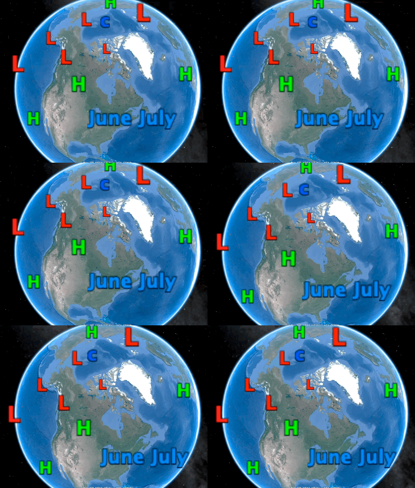
May 2025 projection. A strong presence of the Cold Temperature North Pole, even in a warmed world, there will always be one. C marks the spot the smaller c is the secondary just North of Eurasia. A high pressure should dominate the Arctic Ocean basin area, until early June, the fading jet stream in yellow will collapse at a likewise time. A slowly moving Northwards High pressure will dominate the Canadian American boarder area at about Saskatchewan. North Pacific and Atlantic Highs will substantially add heat to the already warmed oceans. Gulf of Mexico moisture carried by cyclones will also be a common feature all the way to Newfoundland.
A smaller CTNP should lodge just off the North Pole on the Russian side. The ever so present Arctic Ocean High pressure Gyre will switch to a near permanent cyclone mid June, because of apparently extra thicker snow cover, which should transform in ice ravaging melt ponds, but the cylone clouds will be easing the sea ice melt from being extreme. Extra cloud feature alone slows the coming of a catastrophic total sea ice melt event. Warmer Ocean in origin clouds reflect sunlight otherwise destined to melt everything. But the much warmer Oceans will one year overtake the benefits they give. Main summer Archipelago feature will be the rains mainly fuelled by the much warmed North Atlantic and Pacific. The Polar jet stream will vanish early June leaving Northern Hemisphere circulations to languish slowly or stop for days. Again High pressures will dominate Central North America bringing even more warming to the Arctic. Absent Polar jet stream with much warmed sub-Arctic will extend the number of days with heat waves everywhere. The white line over Arctic ocean is sea ice extent at minima. I expect a massive melt despite extensive Arctic clouds. Year by year sea ice is thinning, despite expansive cloud albedo reflections, that is because Maximum is not sparred from warmer winter during the long night, sea ice in March was measured to be all time lowest in history. Hurricanes should languish going nowhere or hug the coast of Gulf of Mexico and East Atlantic, not driven fast but stirred by synoptic weather . Early autumn break from the rain awaits much of the Arctic.Not having a full slate of sun disk observations makes an ENSO prediction difficult, usually sun disk diameter expansions have been linked with a surging El-Nino conversely more numerous than usual sun disk measurements were directly linked with La-Nina. However, I can interpolate, there was a lot of clear days until about beginning of April, suggesting either end of La-Nina or surging one. whether of the 2 was answered in Cloudy April, La-Nina unlikely. I have only one tool left from the sky which helps determine El-Nino, and there was numerous extreme high clouds, beyond 25K laser range. Presence of these gave a strong affiliation with El-Nino, so there is a likely coming El-Nino, if so good for sea ice given the extra clouds will spare extra melting. Despite all this, Arctic sea ice extent at Minima should be slightly lesser than 2012. WD May 4 2025


No comments:
Post a Comment