~2013 minima results needs be explained
~2014 melt gearing up to be big
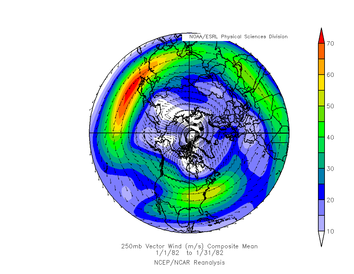
Continuous warm anomalies over the Arctic Ocean have been as incredible as the lack of sea ice compaction last summer. Both result from the same polar vortex wave arrangements, almost unrelenting like UK storms which flood the Isles and head towards the Pole. So I am truly not surprised about current low sea ice extent, it was suggested at the time of last minima by the very same cloudy cyclonic coverage which made the minima bigger. Again the big question is whether sea ice compaction will return come this summer, if it does, I can easily foresee a greater melt than 2012. That is the big if. Something must ward off these cyclones from hitting the High North so often, particularly the pack ice center. This something may be El-Nino or more likely a low sea ice extent area of relatively thick ice in the spring. Once the Polar shores are free of ice, a confluence of regularly positioned cyclones may return the Basin Gyre clockwise. One over Barents and North Pole, the regular expansive Baffin Bay Cyclone and lastly over East Siberian Sea. These 3 will generate an anticyclone covering the remaining Pack ice.
Arctic Ocean shorelines with open water create anchors or stabilizes Cyclones to remain on top of water. A near persistent Low centering the Arctic Basin, same as last summer, may bring a cold spring . Ice clogged shoreline areas favor Highs instead of Low pressure cyclones fueled by water. An earlier than expected shoreline "spring break" of the entire Arctic Ocean sea ice area may change polar patterns though. Weather patterns rarely remain the same forever, when they appear to do so, they set up the new weather system arrangements to come.
Search for "Spring Break" 2013;
"Spring break" is seen when the entire Arctic Ocean pack gyrates almost uniformly, when it appears to be free from its connection to land, the best way to see it is with satellite picture animations, single high resolution satellite pictures do not reveal this event well:
2007 sea ice looked better than 2013 on the same May date. But the end result at minima was different.
Although by May 14 2007, the entire sea ice broke free from shores and rotated clockwise for the first time:
Using available animation, when the big lead off the Canadian Archipelago coast spanned all the way to the Atlantic, the entire ice pack was seen rotating on May 14 2007. It was the beginning of one massive melt of even very thick ice.
2013 had a different look, plagued by steady Low pressure cyclones over the Arctic Basin, which killed the usual compaction favoring clockwise movement of sea ice. By August 2013 the melt was strong but stayed in place, favoring
a wider over all extent of loose pack ice. But by mid May 2013 there was no apparent "Spring Break" until August with available video from NASA.
The entire Arctic Ocean ice didn't appear to turn clockwise at all, it was an anti-compaction melt season.
There were those who believed 2013 was a "recovery" from previous torrid melts. But these suggestions were ignorant about the holistic nature of sea ice. It was not a recovery at all, but another great melt which didn't move normally. A continuous repeat of the same weather pattern causing this unusual lack of movement is highly unlikely. But even if it does, the sea ice will melt just as much but apparently more slowly year by year. But I'd expect the return of the Arctic basin Gyre because the clouds have created a lower extent of thicker ice, this will allow an earlier spring break. WD Feb14,2014