~Coming winter will likely be a warm one for North America
~Notwithstanding ENSO apparent LaNina?
~As far as circulation is concerned the Polar Vortex rules the world
 Take nearly any day in October just past and the vortex would look like above, of which Northern Siberia was/is at the Cold Temperature North Pole (CTNP). Northern Greenland and Ellesmere Island mostly strangely out of extreme cooling business. Largely because of North Pacific incoming warm cyclones driven towards West Greenland by the same Polar Vortex, a feedback loop. If the extreme Southern location of the P.V. is way up in the High Arctic, it goes without saying about the warmer weather further all the way South to Florida
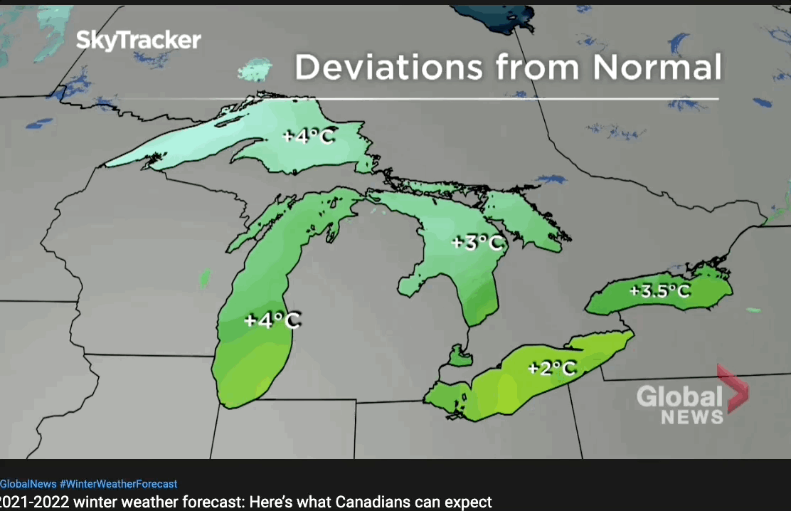
Here is one Canadian Global News long range winter forecast , a fairly descent, standard, run of the mill projection about the coming winter, ENSO dominates the talk, but the Polar Vortex does the walk...
The
NYTimes did a state of the comprehension, quite good piece on ENSO, however it almost triggered the writer, Henry Fountain, to look for circulation pattern causations elsewhere:
......"
The changes in atmospheric circulation can result in changes in weather in various parts of the world, what meteorologists call teleconnections. Much of this is related to the position of the jet stream, the high altitude winds that sweep across the planet from west to east.
In El Niño, the jet stream tends to shift to the south. That can bring rainier, cooler conditions to much of the Southern United States, and warmer conditions to parts of the North. Elsewhere, El Niño can create warm, dry conditions in Asia, Australia and the Indian subcontinent. Parts of Africa and South America can be affected as well.
In La Niña, the jet stream shifts northward. That can lead to warm and dry conditions in the Southern United States, and cooler, wetter weather in parts of the North, especially the Pacific Northwest. Parts of Australia and Asia can be wetter than normal.
La Niña can also lead to more hurricanes in the North Atlantic because there is typically less wind shear, the changes in wind speed and direction that can disrupt the structure of cyclonic storms as they form.
It’s important to note that these are just typical effects. El Niño and La Niña sometimes don’t follow the expected patterns." (underline by me)
What is more to the point is that El-Nino and El-Nina don't appear to change circulation patterns pretty much already set by winter, or can you tell which of these jet stream average positions between January 1 and April 10 happened during El-Nino or La-Nina? :
2 were El-Nino , 2016 and 19, two others under La-Nina 2000 and 08.
Finally recall the forecast presentation ? There is too much certitude over the coming La-Nina, since 2016 ENSO temperatures tended to remain in the neutral temperature zone or at temperatures considered neutral, this was its main routine of late, briefly trending one way or the other never going too extreme. A week or so a La-Nina forecast was in the bag but now:
Not so blue cold.... wd Nov 7, 2021


 Take nearly any day in October just past and the vortex would look like above, of which Northern Siberia was/is at the Cold Temperature North Pole (CTNP). Northern Greenland and Ellesmere Island mostly strangely out of extreme cooling business. Largely because of North Pacific incoming warm cyclones driven towards West Greenland by the same Polar Vortex, a feedback loop. If the extreme Southern location of the P.V. is way up in the High Arctic, it goes without saying about the warmer weather further all the way South to Florida