With a warming El-Nino comes the prospect of more clouds, but irrelevant during warm Arctic Summer because clouds form a whole lot less with much colder Arctic ground and sea temperatures than found further South.
BOM El-Nino 3.0 index finally displays a burgeoning El-Nino after several quiescent activity periods or false starts, from 2011 to January 2015.
1 day apart SST charts july 19 2012, july 20,2015. The North Pacific is way warmer in 2015 as well.
Undoubtedly contributing to a warmer pan-arctic summer. The clouds should overwhelm when the sun will appear lower above the horizon, by end of August.
 |
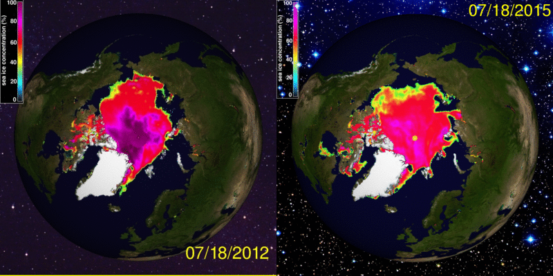
| Cryosphere today July 18 2012 and 2015. Arctic sea ice seems right on track to eclipse 2012 record minima, note all the ice in Kara, Hudson and Baffin Bay seas in 2015, remove it, about 300,000 Km2, as it will surely happen, this makes July 18 2015 area virtually tied with 2012 at this moment . Except same date 2015 has huge more expansive water with Chukchi and East Siberian seas, exactly where it matters the most. Beaufort's attributed 40% cover is a bit misleading as Beaufort opened and closed often by the prevailing winds. From now on, the sun will do much further warming than 2012 on Chukchi and East Siberian, way more prominently in tandem with very warm North Pacific waters. Hudson and Baffin Bay current sea ice areas are but temporary outliers and will vanish soon, they are a product of a dry winter just past. Snowfall helps create thicker sea ice, less of it over the winter meant more sea ice accretion from the setting of fast ice onwards, but also creating lesser ice Extent at maxima where the normal Arctic polynyas exist, these helped create a much more earlier ice free NW passage sea route just about to open. The over all outlook is in favour for 2015 to become new standard bearer for all time minima extent and area, it will be quite obvious soon.  Late August blitz melting of 2014 was sudden because of very weakened sea ice condition, as we can see, this blitz is occurring -now- almost 1 month ahead of time. wd july 21,2015 |


No comments:
Post a Comment