Wednesday, December 25, 2024

Hudson Bay revisit, wide open water Eastern quadrant, less cloud effect.

 ~Surreal open water end of December, Hudson Bay illustrates Earth Warming fast

JAXA Dec 23 comparison , sea ice extent, 2012, 2016, 2023, 2024 ; respectively year of:warmest sea ice melt in history,  very powerful El-Nino, last year, current December 23.


  It is fair to say 2012 greatest sea ice melt in history would take longer to recover, it is equally succinct to demonstrate warmest El-Nino effects should be bad for sea ice in 2016, Hudson Bay started to show even slower refreeze in 2023, but 2024 surpasses them all:

   December 23 2024,  incredible certainly for the people living on Hudson Bay Eastern shores. 

   Sea water usually doesn't freeze at -1 C unless 2 m air temperatures are about -11 C or colder, in especially calm winds:


CMC 0 C degree sea surface temperature line way North.

    Albedo caused by near 0 degree Centigrade fog and clouds gracefully slow down Arctic Ocean sea ice melting totally during summer.   Hudson Bay gets less of this happenstance because it is surrounded by land, once upon a time more frozen for a long period of the year.   Not anymore, since mainly from the West air circulating over drier vast lands eventually sheds its total moisture content, causing more over all sunshine. Equally these lesser clouds over H.B. bombards its sea water to be warmer, the surrounding lands likewise.

       The lesson here is that faced with a lesser cloud summer event, the Arctic Ocean sea ice would pretty much easily disappear at extent minima.  Hudson Bay total sea ice cover, once a beginning of December event, now moves forward into winter not as fiercely cold as it was just a few years ago.  WD December 25, 2024. 

Sunday, December 15, 2024

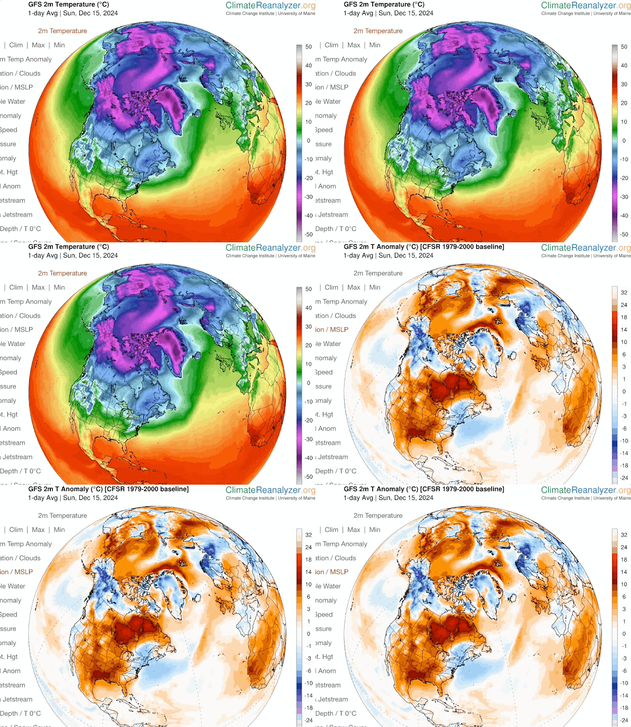
Enormous heat from thinner sea ice blunts and deforms world wide winter circulation

 ~We look at the source of strange weather holistically, but in particular where it is more perturbed.

~Hurricane like heat injects into the Arctic fall and early winter atmosphere simply because Arctic sea ice is thinner. 

  Voyage of the FRAM, Nansen Norwegian polar expedition, 1893-1896.   On the red trail above, Arctic sea ice was recorded to be 3.1 to 3.8 meters thick.

    Same track DMI Dec 15 2024,  gives a thickness nowhere close to 3 meters, something like 0.5 meters at start of famous expedition journey.  

     O.5 meters of sea ice, spanning a huge area gives off close to 100 Watts/m2 heat into the Arctic Ocean atmosphere directly above,  in total darkness,  compare this to CO2 contribution of 4 Watts/m2, consider this warming giving a glimpse of things to come. Remember Nansen reported 3 meters thickness, this capped the Arctic ocean heat transfer almost completely then.

What does this heat injection do?:

U of Maine Climate Reanalyzer,  thinner Arctic sea ice heat injection to the atmosphere, literally shows up almost every day as a warming directly into Polar darkness.  Making a definite very strong contribution to 2 m surface warming.   In turn, the alteration of sea  icescape thickness modifies planetary waves morphology, these are Polar Vortex contortions, greatly affecting weather everywhere onto the warming caused extremes everyone experiences.  WD December 15 2024 


Wednesday, December 4, 2024

Thinning sea ice looks like no other time, but extent results don't show it

 ~  Amazing degradation of sea ice tidal ridging zone in one year

This was the sea ice picture of 2023-24,  the freezing in place of new sea ice, a huge area, not destroyed by daily tidal ridging, the black area North of Axel Heiberg Island  (the Island with Fjords at right)  

   December 23 2023 Polar View High Resolution image of a huge area of sea ice lasting all winter.  A first in the corrupted by AGW Arctic Ocean sea ice. Although winter 2024-25 has not as large fast thin ice area at freeze up,  over all sea ice condition is worse in a vaster expanse: 

  Same area onset of winter freeze, December 3 2024,  but there is an even greater cumulative  area of thinner and broken up sea ice, giving a loose pack ice look North of NW Canadian Archipelago Islands.  This is a view of the last stand of Arctic Ocean summer sea ice, before there are none in summer, what is left of the thickest sea ice is badly broken up.  I suspect that next December 2025 will look even more grim.  This area has great tides from The Northwest, ensuring ridging or the thickening sea ice by the sheer weight of massive sea ice folding ice sheets on top of each other, but if the greater Arctic Ocean pack ice is equally thinner the ridging mega push looses strength as was the case for winter 2023-24

    Heat radiation gained to the atmosphere by much depleted, thinned Arctic Ocean sea ice is enormous. This significant feature will reduce the shape and extent of the coldest Northern Atmosphere  (The Polar Vortex) during winter will affect the climate of every Northern Hemisphere location.  WD December 4 2024  


Sunday, December 1, 2024

Abnormal beyond model warming; One big reason: Slower moving circulation caused by vanishing thinning Arctic sea ice

 ~Interesting article by GSC Gavin Schmidt, a must read:  https://www.nytimes.com/2024/11/13/opinion/climate-change-heat-planet.html

~Most can be indirectly understood if you read my latest of many similar yearly April climate Projections for the summer fall:

https://eh2r.blogspot.com/2024/04/2024-summer-fall-projection-forecast.html

The reason why the warming is greater for the Northern Hemisphere is simple, Arctic sea ice reduction in area and thickness surrounded by continents.  For this we must look at NASA GISS:

                  Annual mean Land-Ocean Temperature Index in 0.01 degrees Celsius
                                      selected zonal means
                                      --------------------
                    sources:  GHCN-v4 1880-10/2024 + SST: ERSST v5 1880-10/2024
                    using elimination of outliers and homogeneity adjustment 

                         Note: ***** = missing - base period: 1951-1980  

                           24N   24S   90S     64N   44N   24N   EQU   24S   44S   64S   90S
Year  Glob  NHem  SHem    -90N  -24N  -24S    -90N  -64N  -44N  -24N  -EQU  -24S  -44S  -64S Year
2021    85   114    55     143    65    53     206   136   127    72    58    72    33    30 2021
2022    89   116    62     152    56    70     235   150   127    62    51    78    40   108 2022
2023   117   150    85     178   106    71     258   187   147   108   105    90    45    62 2023
Year  Glob  NHem  SHem     24N   24S   90S     64N   44N   24N   EQU   24S   44S   64S   90S Year
                          -90N  -24N  -24S    -90N  -64N  -44N  -24N  -EQU  -24S  -44S  -64S
 The zonal mean 64-90 North and South says it all.  There is a continent wide Glacier at the South Pole, while at the North Pole there is a continent size Ocean covered by sea ice.  If this sea ice vanishes,   something likely to happen during a coming summer, temperatures at North Pole Region would warm much more.  At the moment, the warming is gradual but close to 4 times faster compared to the Antarctic.
    A slowing of global circulation is a symptom of massive temperature differentiation from one temperature zone to the next,  as the Arctic sea ice disappears so will the Northern Hemisphere swift weather events usually lasting a day or so, temperatures between the North Pole and Equator will be significantly less, engendering slow to sluggish circulations causing catastrophic events to linger, such as Typhoon/Hurricanes moving slowly over a populated area, as already happened.  Causing entire regions languishing under same weather conditions for days or much longer,  such as excessive droughts, never ending heavy rain periods as has happening more recently again.  
   July peak record breaking temperatures way above climate model projections (NYtimes article) is an indication confirming that Northern Hemisphere is warming faster than the South, largely tempered by massive Oceans and said huge Antarctic Glacier.  There is ample evidence of Arctic sea ice changes, suffices to say, its state is nowhere similar compared with a mere 20 years ago.  Especially autumn and winter ice topography, recently more broken and with open water, along with the warmed Oceans have caused our present delay of onset of winter worldwide.  WD December 1 2024