Thursday, January 22, 2015

North Pacific in Origin Low not as bright than from the South Atlantic.

   January 22 2015,   photo with  moon,  had clear air very similar to Dec 25, 2014.   December 25 sun elevation was -13.12 degrees,  while January -13.09 degrees,  but had twilight brightness well below December 25 2014 Santa storm shine despite somewhat similar mega scale weather.

            ECMWF map describes a pressure ridge from the Arctic Ocean and a minor Low pressure system over the Northwest Territories at pressures 30 mb higher than Santa Cyclone once over Central Quebec.    It was cold over Cornwallis Island -38 C,  while Yellowknife -19 C  very Balmy 7 degrees above normal.  The Ray Path  towards under the horizon the sun had key ingredients for a bright light energy event:

Ray path in black, meant twilight had near ideal temperature contrasts to generate more light for those living in darkness 24 hours a day.    But this low had lesser energy stored in it than during Santa storm.   The proof was in the twilight.   This latest observation continues  proving even more the great capacity in judging how strong a cyclone might be when juxtaposed to a dark zone.  With better equipment the same thing can be done with hurricanes or any high energy storm system.   WD Jan 22, 2015


Saturday, January 10, 2015

Confirmation, Higher energy weather systems are brighter

~Similar weather patterns gave darker twilights
~Difference in temperatures between Low and High pressure systems is what matters


   Simplified explanation:

   A high energy weather event exists when it has more heat or overall greater kinetic (molecular motion) energy than adjoining Pressure systems.     On a modest scale, hurricanes or typhoons are high energy systems,  on a macro or very large scale Cyclones contain large quantities of heat usually characterized by moisture content or much warmer temperatures along with wind motion.  A warm cyclone having gathered heat over a warmer Ocean source, can create more light channels especially if it heads towards Northern usually always colder High Pressure systems.   These channels are  similar in nature to fiber optic cables which carry light by refraction.    A cold system immediately next to a warmer one naturally creates channels at the interface between colder and warmer air.  The sunlight present
at many such  interfaces can get diverted like a laser light through fiber optic line,  and travel beyond  the earth's terminator, the edge between light and darkness separating night and day as seen from space.  In the High Arctic at present it is dark,  but a twilight exists at noon.  This twilight changes in intensity due to the position of the sun below the horizon,  the extent and type of clouds, pollution or natural aerosols, and finally how much refraction there is in the lower and mid lower atmosphere where normally the Arctic Air is warmest in darkness.


Confirmation of Pressure system driven light variations due to atmospheric refraction.

~please read the Christmas article just below,  this is a follow up.


   December 25 2014  (left),  was visually brighter than January 9 2015 (right).  The sun elevation was -12.07 and -12.12 degrees.   On camera ,  the visual perception was confirmed.  With exact camera settings and location in both instances.


    A bit later, December 25,2014 (left) and January 9,2015 (right) appear similar,  but there are large differences.   First the hills appear higher on Dec 25,  this may be an illusion due to brightness.   Second ,  despite January 9 more sparse lower clouds,  there appears far less redness, a feature of the raised horizon, purely a refraction and scattering phenomenon.  If there were more aerosols on either photo,  the red would have appeared hazed, or more uniform ,  but instead it was layered in refraction dispersion colors.
January 9 lack of redness was likely due to lateness of twilight.   When only white
light appears.    Finally Dec 25 sun elevation was 0.3 degrees lower than on January 9.
Remarkable demonstration on to how bright Christmas day twilight was, especially since
January 9 had very clear air,  especially cleansed by a 2 day blizzard,  and the temperature  was colder over he same wide area light has travelled.  Colder air gives stronger refraction without ducts.


Weather Prognosis


    Since before December 25,  several Atlantic North-easterner Cyclones have merged into a greater huge sub Polar vortex roughly centered over Greenland,  affecting weather over a vast areas spanning from Arctic Eurasia, Scandinavia all the way to mid-west USA.    Since Christmas,   the temperatures dropped significantly over most of North America,  with temperatures higher in he High Arctic.  Clearly a reversal in contrast has occurred,  instead of a wide deep in dT  macro interface  as on Christmas,  dT were largely diminished.  Pressure systems were equally not entirely similar, December 25 had a large intrusion of warm air spanning westwards past Hudson Bay. January 9 light path Cyclone was not so significant East of Hudson Bay.

     A very similar prognosis to Dec 25,2014, misleading because temperature Upper Profiles were very different.    The  Polar Vortex had 4 components,  in 2 small anticyclones amidst 2 larger cyclones.  The biggest Low centered over Greenland basically a sub-vortex covering half the North circumpolar world.

December 25,  90 W degree longitude line (the only vertical one) demonstrates  large difference in Upper Air temperatures,  up to 30 C dT between 600 mb (left) and 1000 mb (right).   This is what gives more light.   As opposed:


January 9, 90W transect had a much milder dT but still quite significant.  Therefore less light but still a lot.  THe difference in twilight brightness proves yet another very useful
refraction method,  this time in judging the magnitude of Cyclonic systems.
The December 25 event,  not giving destruction as dramatic as a hurricane was very important not only in revealing twilight brightness effects, but also in affecting the weather over a vast segment of the circumpolar world for weeks to come.  WDJan9-13
2015

Thursday, December 25, 2014

Christmas brightest twilight signals great thermal event 2000 miles away

 
  Southern Cornwallis Island Nunavut Canada  had several days,  almost a week without clouds,  adjusted my eyesight well,  but what I saw verged on the impossible, or the possible but never noticed.   The picture with layered segments above are of the same twilight,  except the first one (top),  was taken earlier on December 22 2014, more to the East towards the sun position,  the two others below were taken in the same direction towards the sun azimuth location later in the afternoon of December 24  (middle) and 25 respectively.   As weak as twilight appears here,  it was in fact brighter to the naked eye.  But the same camera was used in order to demonstrate and record this refraction event.      The first segment was taken when he sun was -10.20 degrees below the horizon.  It seemed normal or close to the average twilight look at -10 degrees.  What caught my eye was the second segment,  at -12.13 degrees the horizon twilight was brighter than at -10,  a fantastic re-discovery (the Y-V Ulluq Q),  but this time captured with identical digital camera settings in every way.  It is hard to accept that a much lower under the horizon sun can produce more twilight in clear skies.  But horizon refraction often does so, but in this case can be considered a wow moment.  The physics involved  require a deeper understanding of how much heat this cyclone carried.  Heat  and cold are a major component of Atmospheric refraction.  However, for North Eastern Americans and Canadians it was more heath than usual.

     Further to the South an important cyclone has moved from the South Eastern US December 23  all the way to Central Quebec on the 25th of December.   Some called it "Santa  Bomb".  As this cyclone approached the Arctic the twilight brightened.  In fact brightest on the 25th.

    The second camera used replicated vision much better,  this was the 24th,  the cyclone approached polewards and injected a lot of heat,  this heat overlay over Arctic colder but seasonal air and caused an inversion interface at likely 2 altitudes,  one on the ground,  and the other at the maximum temperature in the upper atmosphere. On the 25th the horizon with sun at same altitude was remarkably brightest,  a Christmas like none other for long night people.

      Several magnitudes of twilight brightness increased in a mere few days,  the location of the major Cyclone varied from more than 2000 miles away and 1500 miles South South East when December 25 picture was taken.     One must consider the staggering amount of energy needed to create such an event,  and especially the extent of reach
one pressure system so far away may have.   I believe that this storm had more to it than calculated.


    Proof is in the position of the Christmas storm, temperatures in the Arctic did not vary
greatly, under a steady high pressure ridge.    The only variant was the Low American  North Eastener heading off its usual Ireland and UK track towards the Pole.

       Camera 2 sequence,   on day 24 the Low was further away NE USA,  day 25 maximum illumination due to closer proximity of Santa storm still warm (central Quebec).  Day 26 fading,  the storm lost a great deal of energy  on its way to Hudson Strait and thus the interface dT's, temperature differences were lesser,  from here on Arctic twilights will vary less bright until the next warm massive cyclone Polewards.  

Just How much more energy did the "Santa Storm" carry?


    Extra Light carried through  was not only due to its size,   but because of contrasting
weather powers,  the anticyclones  vs the santa-cyclone,  if the cyclone was  run of the mill standard and without much exception,  then it would have headed to Ireland and  UK  like the previous dozen or so.   Instead it headed more North,  clustered by Highs to the East West and even North of it :

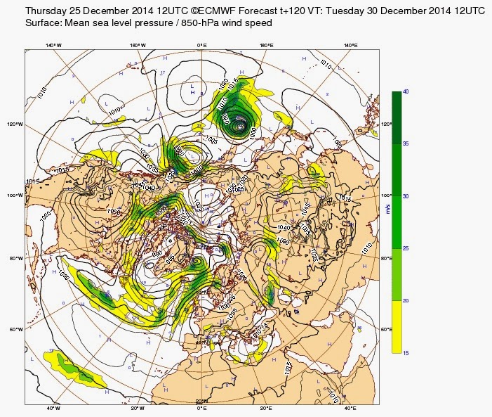
 ECMWF Dec 25 2014 at 12z.        Extent wise this low seems modest.  Yet
there was a great deal more light high up in the Arctic.   The even more modest
High pressure ridge near Cornwallis offered no apparent clash to the titan much further South.

  The one week forecast made the Low merge with pre-existing left overs from previous North Atlantic incursions:

The "modest" santa low as forecasted really became  a North Atlantic Monster swallowing Greenland.   The forecast serves as a measure of energy,  if the santa low
was correctly evaluated the forecast would reflect this measure of accuracy.

          By the looks of it ,   the forecast was pretty impressive,  but there was more energy in the same date time surface analysis,  suggesting an under evaluation of the
total amount of energy a week prior.  

 WD December 25-26, 29 , 2014

Friday, November 21, 2014

new REFRACTION method reveals Arctic Atmosphere morphing to allow more Cyclonic penetration

~Interface Adiabatic Index dwarfs its opposite Interface Inversion Index by 80%
~Method exceeds any other technique in identifying what is happening at the most crucial interaction  between Earth surface and atmosphere.


   The larger question given by a warming planet is what happens to Earth aside from its climate heating up slowly.  The answer is at the interface.   In darkness,  the surface to air interface is cold, very cold,  the land or sea ice becomes a reflection of radiative cooling. Eventually  exceeding,  overwhelming what heat is left in the lower atmosphere.  However,  air is a good insulator,  in this case the usual  layers a top the interface remain warmer,  this causes inversions.   The rate of cooling or lack thereof can be judged by how strong the inversion is.  Extremely thick sea ice over the Arctic Ocean mirrors land during the long night especially after land exhausted or radiated most of its energy to space.  Ice some 10 meters thick has very little heat lost to space.    Thinner ice has
much more radiation escaping,  this flux of energy alters the climate terrain.   The lost of thick sea ice has already affected the climate worldwide.   In the Arctic past, winter was built by darkness with a sea largely non existent, in effect insulated by sea ice,  the lower atmosphere lost its heat upwards to space in Autumn, Winter is created when land and sea ice accelerate this cooling process  by heat radiation going at times 2 ways,  upwards towards  space and downwards towards much frozen Earth.


    Most remote sensing instruments do not read physical bodies next to each other extremely precisely.  As an example,  the air right above open water ocean is often not the same,  the remote sensing achievement in determining temperatures at 5, 10, 100 or 200 meters above or below the sea surface is outstanding.     But as I wrote before ,  this precision may be questioned,   how we measure the temperature of everything at once is a matter of future progress.  What the horizon refraction method does is quite unique,  singularly a measure of the physical or thermal process at the interface at once.  Its precision is unquestionable.  A true measure of the temperature of the entire atmosphere is the dimension of the vertical sun disk, the most precise temperature measurement of the entire atmosphere in existence,  but the thermal nature of the surface interface seen at once is invaluable.


    Warmer November 2014 lower atmosphere (left) and sea ice (Right) over Chukchi sea was directly responsible for almost burying Buffalo NY state,  the jet stream went way North roughly following this warming anomaly.  How to explain  this possible when in 2012   there was far lesser sea ice at minima with Chukchi sea ice  in 2012 colder?  :

Courtesy NOAA.....  So we are suppose to believe that the ice surface near Chukchi sea
in 2012 went just as cold or colder from an area which had wide open water as compared with 2014 minima apparently not having such a  great melt?  


The presence of thick ice does a remarkable transformation of the horizon as opposed to a body of open water or very thin ice.    From this literal point of view,  the interpretation of interface thermal physics can be judged instantly.  Observations 
so far this Arctic fall reveal a predominant IAI: Interface Adiabatic Index,  meaning 
the interface from ice to immediate lower atmosphere being adiabatic,  not
fostering inversions describes thinner ice as the area of observation is directed towards the sea.   Other methods of measurement usually are oblivious to the interface mixing zone,  being blind or oblivious to the IAI gives room for plenty of strange misinterpretations.  Now that I know that the IAI is overwhelmingly high.  
I understand that any cyclone can easily venture further North,  as was the 
case in he North Pacific Low in part strengthened by a typhoon, this Cyclone of a week past can also advect warmer air,  compounding the IAI to last much longer.   The opposite III ,  a predominant long lasting Interface Inversion Index means winter in progress,  the very nature of cold air 'construction'  or progression demands 
a consistent III,  which would repulse and rather chase away any Cyclone.  
III at present is very anemic....

wd Nov22,2014
and therefore   

Wednesday, October 15, 2014

The sunline on the lunar horizon

~Lunar horizon glow looks eerily similar to the sunline on Arctic Earth


                      Surveyor 6 , November 6 1967 lunar sunset on the Western horizon.
There is something very familiar about this,  of course its the sunline.   But wait there is
apparently no atmosphere on the moon.   The theory suggesting electrically charged dust causing a sunline is questioned here.  Of all EH2r records from a significant database of Earthly sunsets (from polar and temperate zones),  none have given a sunline due to dust,  it does not happen.   Sunlines are a pure atmospheric optical refraction effect.  


      To the untrained eye, it is hard to say which of these two pictures is from the moon or Earth,  the moon shot (left) should have a pitch black sky, and the Earth's brighter atmosphere gives away the polar sunset (right).  There is no doubt about moon dust on the lunar picture (left) given by the small aureola, similar to haze or dusty horizons on Earth.   But the sunline is unmistakably identical.  The rocky lunar surface is very similar to the sandstone Arctic gravel hill 3.5 km away from camera:


Arctic hill sunset October 14, 2014.  Remarkable
refraction effect caused a few km away,  not through a long distance of atmosphere.  But caused by air less than half a meter above the gravel hill.  It took very little gaseous molecules to cause this effect.

There was a very faint or negligible corona  because there was no dust or ice crystals (it was too warm for crystals to form).  There was light winds as well,  frozen ground reduced dust levels greatly almost completely.

   The absence of dust here contradicted the presumption that sunlines
are caused by dust.  They exist because of gas.  Until a dust sunline can be replicated,  a dust sunline is simply an un-observed theory on Earth.

    There is an unmistakable structure with any sun line,  if you zoom you will see red line layered below the brighter yellow which can be at times blue or green.  The red has to be below because there is less bending of red light,  it is a refraction effect.  Consider the same photo with no significant atmosphere and the line would appear greatly brighter than background.

  A careful look reveals almost identical sun line between Earth and moon,  the difference is of course in part due to different optical equipment utilized.  The moon's aureole was illuminated by moon dust,  but the sunline is a totally distinct feature.  Has nothing to do with dust as seen on the edges of the moon's sunline especially at left,  where the aureole dust above hardly makes a glow.   There is also a photonic disturbance below the main brighter moon sunline suggesting a red imprint of course not recorded as such.
 
     The actual physics of dust bending light uniformly would be quite exotic,  unless unique to the moon,  dust scatters light when photons are present.  The theory suggesting
that light gets bent,  creating a later sunset, indeed introducing focused photons making a layer of the micro horizon bright  has nothing to do with particulates.

       It is not inconceivable that the moon may have some daily outgassing similar to comets during their celestial orbits approaching the sun.   On the lunar surface there is a daily very steep rapid change in temperature,  a heat cycle familiar in the Arctic,  where micro surface thermal variations are responsible for great photon redirecting.  There is also an atmosphere on the moon,  said to be very weak,  13 degrees of magnitude weaker than on earth,  perhaps not always the same or uniformly everywhere on its surface. WD October 15-16, 2014

Sunday, September 14, 2014

Extremely late in season spontaneous sea ice melting

~ Even when expected,  the look of vast sub-zero air sea ice melting astonishes


   In merely 3 days,  with air temperatures not so favorable,  a few degrees below zero degrees centigrade, but above average for this time of the year,  the greatest melting action so late  demonstrates the real nature of 2014 melting season,  which was really influenced by 2013 great cloud summer event.  To recognize a a wider recovery of sea ice,  one must see it more expansive than the year prior, and more thicker.  Piomas may recognize a thicker ice,  but the extensiveness is largely different than 2013,  when the ice melted in place without compaction.  The net difference is insolation of the open water around the lower latitudes of the Arctic ocean,  a recovery would not allow the sun the warm up sea water particularly at these latitudes.   This invites the stalling of accretion,  an eventual less thicker ice at next maxima. But also this scene shows that ice may vanish with air temperatures below 0 C.  This is a key factor in the coming wide open Arctic Ocean,  sea temperature in turn to be excessive,  warms up the ice to a critical temperature point.  When reached the ice simply vanishes,  the sooner it goes in spring time,  the greater the melt in autumn.  WD September 14, 2014

Wednesday, August 27, 2014

Spontaneous meltdown, a matter of ice temperature.

             North of Alaska new rapid melting area 120,000 Km^2 appears sudden,  but is more something to do with water and sea ice temperature.   Note buoy 2014C likely floating about in the wider open zone to the West , is reporting -1 C water,  likely enough to help further the thawing process.    What appeared more solid a mere 6 days earlier almost disappears overnight.  Despite -2 C weather,  which is permeated by a Low pressure system.  Sea ice appears most fragile when  the ice temperature is equal to surface water,  particularly at this time of the year.  The total accumulated heat by open water won't go rapidly,  only very cold surface air temperatures will stop this process.  WD August28,2014

Wednesday, August 20, 2014

40% ice? Resolution at Cryosphere Today radically misses wide open water .

           Cryosphere today ,  August 18, 2014 .  Infamous McClintock passage of the NW passage.  The same channel responsible for the death of 126 sailors of HMS Erebus and Terror fame in 1848, during the said "mini ice age".  Notorious for its perineal rough and thick sea ice until about a decade or so ago, it now opens completely every melt season.  So as some say, 2014 melt is similar to a "recovery" or archipelago sea ice looks massively menacing and a return to a clogged NW passage of old.  Well CTpresentation, as above,  may hint that there may be some form of return to the past.  Not so:

NASA Eosdis view of the same area August 17 2014.  The Channel Prince of Wale shore has more than 20 nautical miles of open water, with very little ice,  not at all as presented by CT.  This probably means that CT uses grids in excess of 20 nautical miles.  Of which if there is 15% of ice the data would evaluate a wrong Area number.    So now the Passage is about to open by winds and further melting. But using CT data one would leave his boat moored in Baffin Bay or Cambridge Bay rather than attempt the passage at all,  and eventually return to the South if using the same coloured map.  WD August 20,2014

Saturday, August 16, 2014

7 day ice melt, as fast as it goes, but late in the season

Despite clouds NOAA Visible wavelength sat pictures clearly depict rapid melt and clockwise rotation of North Beaufort Sea Ice.   The wider open clear water near Banks Island is August 16 (compared to August 9 1 week earlier),  there is no ice to draw from this Island, therefore the ocean appears really clear,  the rest of the August 16 picture is veiled by clouds.  The big 160,000 Km^2 North of Barrow circular melt  has lost most of its broken internal ice,  may be not enough to register on the CT Area data, clouds don't help showing that it expanded as well. WD August 16,2014

Monday, August 11, 2014

Rapid disintegration rate may not be measured accurately because there is more than 15% of sea ice left.

   There is lateral displacement of sea ice every where as seen here for NOAA visible pictures between August 9, 2014 (mostly clear) and August 11, 2014  (large clouds with shadow top right).  What is seen is a new large area of open water about 160,000 Km^2 (on the 9th) just North of Barrow Alaska,   expanding rapidly wherever there is ice,  but it easily has some remnants in extent more than 15% which will not let this expanse be measured in area until there is > than 76% of open water.  This leaves measurement metrics a bit off, and particularly strange, when we can see great melting but no daily records of it can be noted.  Eventually when there will be less than 14% of ice left in open water zones the drop in extent and area will show rather large on daily data records as seen on JAXA or  Cryosphere Today.  But the area to the South of Expanse has roughly 50% water, all of this is considered as 100% ice. WD August 11,2014


    Rapid ice shoreline melting

August 6 NOAA image (with clouds lower left) compared to August 11 PM NOAA demonstrates rapid melting in progress at every ice edge.  But envelopment must occur first.  The main process of compaction is 2 pronged,  first the main pack is pushed together,  then the ice shore scatters with thicker ice moving inwards faster,  leaving thinner ice behind (by winds).  The thinner ice gets enveloped by warmer sea water when exposed to sunlight.  The ice, known by buoy data, is at the same temperature
as the sea surface,  any warming obliterates it to water.   A second melting process,  quite interesting by its look,  may be a precursor to a complete melting of larger chunks of sea ice.  A melting occurs in the middle of a pack,  likely because there was thinner ice laced with leads there.   Thawing spreads outwards by sunlight warming sea water ever more so taking hold of the region.    Compaction moves the ice as a whole,  warmer water reaches the scattered ice and envelopment is amplified.    Again the rate of melting is extremely fast,  considering the ice appeared to have withstood the onslaught of summer hardly unscathed,  but it is not so, sea ice was transformed, from hard and cold to as warm as sea water and soft,  ripe for elimination.   In 2007 this process occurred earlier with a combination of warmer weather and total insolation which devastated the thickest pack ice very quickly.  But same process,  even with lower cooler sun, it happens just as much.  WdAugust11,2014
Clouds forgiving us a sight, NOAA August 6 to 12 visible picture again brings out a clear break down
of shore ice vanishing as quick as I have ever seen it,  thanks to buoy data, we know why,  again data remote sensing numbers don't suggest,  not even a mere hint of this action.  So the proper interpretation
of ice status is not 2 dimensional but 4, consisting of area,  thickness and  temperature.   A glance of larger ice extent does not tell the whole picture. For instance,  the ability of sea ice to change the weather depends on its temperature,  not acting as a heat sink affects Global Circulations which in turn affect the pack same as any meteorological feedback mechanism.  wd August 12, 2014