~ Winter 2021-2022 story to date, CTNP shifts from Siberian dominance to the CAA and returning to Siberia.
~ Canadian Archipelago recent dominance is fading fast.
The larger question throughout winter is always explaining the reason for Cold Temperature North Pole location at any given daily location. Turns out 2021 early winter Siberian dominance may have been caused by Arctic Ocean having more open water, hence more snow, onsets early winter there, On Canadian side of Arctic, winter was delayed by incredible warming and less snow, unusual considering last few years same periods.
Early Winter CTNP Siberia shifted gradually to Canada, largely because
it blew cold continental air across the just frozen Arctic Ocean, in a river of cold air, clearly seen above and below. This flow was unstoppable, the Siberian Polar Vortice assured this. Eventually
the very moist flood giving Pacific North American flow of air was cut off by a huge stable Pacific High, in part created by this flow. This formed new anticyclones East of the Rockies which rapidly sent the Prairies in a deep freeze, https://edmonton.ctvnews.ca/nastiest-deep-freeze-in-edmonton-in-over-a-half-century-1.5732278. the stable cold clear reverse feedback cooling air at 40 to 50 degrees North latitude over not so much snow covered land can go in a deep freeze fast because the sun is low in elevation and the nights are long in January. This deep freeze eventually joined the real area of very cold North American air in the CAA, causing the first strong North American CTNP vortice, dominating the Northern world. However, the incredible North Pacific blob of warm water temperature finally was returned by no less than the CAA CTNP, another quasi permanent West to East circulation. Now North America is facing a warming caused by the very center of coldest air apply placed about Hudson Strait. As we can see below, North America is about to warm substantially with a far weaker CTNP core vortice:

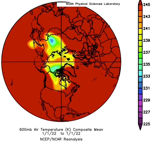
A weekly NOAA composite summary of 600 mb temperatures brings out what is to come. Cold air may be stable next to a giant iceberg, Greenland, but is very vulnerable if pushed over the Atlantic, as it has been during the last few days, but before it vanishes, the warmth of the Pacific has been dragged over much of North America. This moist laden heat flow will eventually stall, and the last remnants of a weak winter may barely reach a wide area, I'd expect a weak CAA CTNP vortice as already confirmed by sun shots, giving about average differential refraction sun disks. As the loop above shows, the extent of Polar Vortex cold air is rather small, guarantees a shorter winter, early spring. WD March 6 2022