Wednesday, August 31, 2016

Atlantic Front retreating, likely because no substantial replenishment

~  And Goodbye Waves Palooza everywhere signifying great melting


   If the  Trans Polar Stream has less ice,  it also means less momentum and continuity pushing sea ice towards the Atlantic,  this is what we are observing with JAXA August 27 through to 30 above.  Hence a retreat throughout the Atlantic Front and even if not seen with HRPT photos,  a lot of Goodbye Waves signifying  rapid melting.  It is a reverse flow mirage which has something to do in part with the broken off flow momentum pushing dense sea ice outwards and Cyclone Centre pushing winds Eastward.

   Its a mess on the other side of the pack,  with Goodbye Waves galore,  the ex-Wrangel Ice bridge is rather a modern Art collection of rapidly disappearing sea ice. WD August 31,2016

Tuesday, August 30, 2016

Wrangel Island ice bridge no more, its a messy combination of very thin broken sea ice and Goodbye Waves


       Goodbye Waves can give a problem with determining wether they are sea ice or as they really are slush:

Goodbye Waves along with very thin emaciated ready to melt sea ice near Wrangel Island August 30, the thin ice almost looks like goodbye waves but they are not quite alike.

August 27-28 ,  JAXA depiction is fairly good ,  but there is a mix between Goodbye Waves and sea ice, seen on 28 apparently having more sea ice,  although the two are from sea ice, they are definitely not alike,  the prominent gap breaking up the ice bridge in two is more prominent on NASA EOSDIS capture (above),  the bridge is no more,  what is left is going goodbye.


JAXA got the Gap almost the same with EOSDIS  on August 29

Goodbye Waves likely caused this confusion.  Look at the 2nd arm of the ice bridge reappearing on August 28.  


The ice bridge collapsed quicker by the cuts of many cyclones,  it was already impossible to walk on
it late July.  It now exists like glue holding 2 tons together.  WD August 30,2016


Monday, August 29, 2016

Cyclone centring by sea ice footprints? Another North Pole hole miss

   North Pole proximity had the visit of an important cyclone approximately 974 mb for about half a day.   Again a great deal of open water was created near or at its centre.  This prompts the idea of cross checking the real cyclone centre with sea ice imprints,  the same goes for very High pressures.

    The larger state of current sea ice deteriorates further late in the season as well.August 29, 2016 wd

Sunday, August 28, 2016

Canadian Side usually ultra dense sea ice observed loose up to 89.5N

   The latest August 28 974 mb cyclone is very near the Pole,  and this time it should create quite a lot of open water there because the Canadian side of Pole sea ice is now likely the least dense observed in history.  WDAugust28,2016

Wrangel Island ice bridge methodically becoming no more.

~If it all melts,  2012 extent record will be seriously challenged or exceeded


    Within last 4 days,  the Wrangel Island ice bridge has lost about half of its extent,  at this rate it should be all gone within a week,  since the water surface to ice ratio increases every day:


Once the middle of Wrangel Island ice bridge to Pole becomes water, likely in a few days if not tomorrow, the melting will accelerate.   Comparing to 2012 is of interest:


     There are huge differences between the icescape of August 27, 2016 and same day 2012.  2012 had an ice bridge to Wrangel but disappeared earlier,  North of Laptev sea ice was only present above 80 N,  the Atlantic front was more to the North.  However 2016 has a deeper towards the North Pole sea water bite and has incredible CAB lower density sea ice areas :

   The over all up to date review suggests 2016 capable of surpassing 2012 in its own way.    Melt years are rarely alike,  even one following another.  What makes 2016 apart,  is that it happened significantly without a prolonged Arctic Dipole,  in other words, without a great deal of summer insolation (and its cooler in summer when cloudy,  even in the Arctic).  This was a prerequisite proving that warming Global Temperatures need not have favourable weather conditions to devastate the existence of Arctic Sea ice.  WD August 28,2016

Friday, August 26, 2016

Trans Polar Stream, first time so wet in history, is simply huge, it may cause a fluid mix accelerating flushing to the warm North Atlantic.

   A  gap in clouds drifted long enough to reveal a huge area of sea water mixed with loose sea ice just South of the North Pole (about 100 nautical miles),  NOAA HRPT.  Of interest is the zone between this opening and Fram Strait,  which has always been a fluid area of sea ice, usually slowed by traffic jams of ice coming from multiple directions.  However, even in winter, this is an area rife with movement.   It may not be strange that it looks more dense with sea ice,  it all bunches up there,  but it is not a static zone especially now:

   Fram Strait is rapidly bulging Southwards with sea ice,  this means that the Open Trans Polar Stream may reach the Strait,  with 0 to +7 C sea surface temperatures.  Notice Goodbye waves between Greenland and Spitsbergen Isles,  they expanded from August 23 to 25 as well,  a sure indication of rapid melting along with the arrival of new sea ice.  If the Trans Polar Stream open zone reaches Fram Strait,  it would mean a much more fluid flow of sea ice to the North Atlantic.

   Note the zone of open water within the Trans Polar Stream appears far more ominous on Satellite pictures,  this is due to AMSR2 15% minimum sea ice per grid rule.   However, any increase in fluidity North of Greenland or Spitsbergen would accelerate the flushing of the real last remnant of dense sea ice North of Greenland as the mixing mashed up zone of subduction would have no pressure from the Trans Polar Stream furnishing usually thick ridged sea ice,  this acceleration may have already started.. wd August 25, 2016

Thursday, August 25, 2016

The Trans Polar Stream is becoming like a sea water river carrying loose sea ice to the Atlantic

   
Note the ice pans moving from left to right (August 18-25),  despite many strong cyclones giving different wind directions,  the Trans Polar Stream seems largely unaffected.  As time goes by,  the ice pans near the North Pole, 87.7N 107E,  become more and more surrounded by sea ice.  This is a very precarious moment,  the stream is almost loose like this all the way to the North Atlantic,  from 85 N to 82 N there is denser sea ice,  if this barrier or ice dam collapses,  nothing will stop a whole lot of ice of melting further,  unfortunately the forecasts call for strong winds over the denser sea ice barrier region.  WD August 25,2016


Wednesday, August 24, 2016

Huge sea ice area is on the Razors edge, between water and survival

                                 
There is a sea ice lake,  the size of  Lake Superior, 85N 135E,  the remnant of GAC3 again dispersing ice at Centre of this Cyclone.  The Wrangel Island ice bridge seems on the verge of total collapse.   The other, towards Laptev sea,  only has less than 1/3 of its pack apparently solid.  The Atlantic Front appears to be moving North.  There is significant extent numbers consisting of 80% or more of seawater,  which would count as 100% sea ice.
  The entire Eurasian sector of the Pole is very fluid by the presence of a lot of open water and has had a significantly changed icescape especially towards Bering Sea in 10 days.   More movement of sea ice is within denser sea ice areas in the North Atlantic sector:

  Daily Sea ice with open water movements are visible enough despite partial cloudiness,  some areas have modest displacements, some appear steady,  this water and ice displacements affects the look on the JAXA map above. WD August 25, 2016

Tuesday, August 23, 2016

Goodbye waves lack of geometric continuity, drastically different than melting Fram Strait sea ice

    Goodbye Waves,  not showing on JAXA at all, congrats to AMSR2 people having fantastic banzai uber precision,  have shown remarkable geometric contortions in Fram Strait,  all while not readily being identifiable from one day to the next.    Point your mouse cursor on small ice pans and note their lack of motion very unlike the Gwaves, fascinating.  WDAugust 23,2016

Monday, August 22, 2016

North Pole Sea ice: what we can see 2016 is bad, 2013 visually worse, but 2016 is it

     2013 summer was mystically confusing,  2016 more straightforward,  at first glance 2016 here appears lesser North Pole affected than 2013 on August 22.  But AMSR2; "The Advanced Microwave Scanning Radiometer 2" captured otherwise:


   Here we fall into the 15% sea ice minimum extent per grid delusion, which in effect even the best system does not capture the holistic picture, by set of standard rules. We must always combine all data sources possible to obtain the holistic construct to have a better understanding of reality. Unlike 2013, 2016 exceeded the 85% threshold for open water. 2013 had much more ice density despite North Pole area pack Ice being flooded with open water, perhaps if the grid was made smaller, 2013 would show up somewhat worse than historically presented. WD august 23,2016


Compaction vs scattering, sea ice movement favours some extent gains on the leeward side until spreading gets water to be prominent.

   August 20-21 JAXA sea ice extent map,  has a particular feature of interest.  Sea ice extent drop was largely diminished on 21 august,  despite larger sea water areas.  Note the rotation of the remainder ice pack. Notice stable sea ice shores on the wind compaction side,  but the leeward side is scattered and badly broken,  there is no ice to stop movement but sea water,  the ice spreads out and gains overall extent amidst water not exceeding 85% coverage per grid.  Test this out by placing your mouse cursor on the leeward and windward shore lines.  There are significant gains in extent with badly broken up sea ice vs compacted areas almost apparently not rotating counterclockwise.  Extent figures will eventually drop much further when the scattering isolates the loosened ice pans further for melting in warmer water.  WD August 21,2016

Sunday, August 21, 2016

Towards the left, captures file.

~"to the right" of wind direction-   -+ sea ice dispersion is not easily captured.
~ here we have "to the left"  compaction by GAC2

   Despite clouds  large ice pans were moving to the centre of GAC2 2016.   Winds go from top to bottom of frame.  Located just NW of Banks Island Canada,   Sea ice is converging towards centre of the Cyclone.  WDAugust21,2016

Saturday, August 20, 2016

2016 signature characteristic: Sea ice floes not moving very fast

   JAXA latest 44,840 km2 apparently daily drop of August 20,  did not come as a surprise, a new GAC seen here elegant and spinning a storm,  lets call it GAC2,  is relishing the temperature contrasts between open water and sea ice air.  This NOAA satellite capture,  4 hours apart from the first frame (1450-1856UTC),  shows an intense see-through cyclone,  see-through because it was  largely over sea ice while dragging extremely slowly a lot of loose floes readily available, you can notice the largest ones barely moving by placing your mouse cursor over them.  This has been a main feature of 2016 season,  the Gyre current has been stubbornly opposite to the winds often,  even very strong winds.  But there is a daily movement at variance with winds and other geophysical motion vectors nevertheless, largely captured on JAXA maps featured almost daily here.  Today,  North of Beaufort open water is getting more sea ice, not broken up the same way as with GAC1.   Therefore the extent rate slow down,  a signal from a weather circulation variation,  what comes next is another huge drop.WDAugust 21,2016

Friday, August 19, 2016

Challenge to #1 minima, Sea Water conquering by dividing, fraying sea ice at the edges

   There is a huge amount of scattered shattered sea ice,  nearly about 1/3 of the remaining pack has loose fluid  cover,  if it all goes to water,  minima would be a dead heat contest with 2012.   It is no longer a top 3 year,  but currently it is within top 2,  2016 is in virtually same extent tie to 2007 as I write.  The Wrangel Island panhandle is almost completely frayed,  and should all melt in the coming weeks.  The sea water lakes near the Pole can only expand further from a significantly new Cyclone to come.  Extent drops will soon be all time highest for days.  August 18 84,635 km2 loss is only second to 2015.    This brings the matter of autumnal cooling,  which no doubt will arrive delayed due to all the open water everywhere.  This greater area of sea water has profound implications to Arctic temperatures,  the making of winter itself should be later.  wd august 19,2016

Thursday, August 18, 2016

2nd day GAC, North Pole situation looks more open than ever

~Sea ice rotation "to the right" of winds,  does not show up so well,  scattering seems more isobaric
~ Melt rates vary in steps associated with Low pressure movement.


CMC GAC yesterday august 16 at 18 UTC


CMC August 17 18 UTC surface analysis.  981 mb situated 82N 150E not moving Southwards anymore from this time ,  at 00 UTC the centre was 82N 155E, 983 mb.  This means that a new batch of sea ice was broken up further and or at different locations since yesterday.  Note the isobars,  and look at the rotation of the entire sea ice pack carefully:
JAXA   Map Clearly shows very little outward dispersions,  but very much sea ice movement following  Isobaric lines more closely.  The centre of the Cyclone stayed long enough at 86N to cause extensive water zone not readily filling up with scattered ice. You can even notice the isobaric lines etched in sea ice just South of the Pole towards Alaska and Bering Strait.   The new Low pressure centre has dragged a new batch of sea ice along the  Ostrov Komsomolets Eastern ice bridge shore to cover open water, this accounts for a reduction in  extent daily drop to 73,373 km2 (3rd greatest melt for aug 17 since 2002).  Note the great scattering of sea ice along Wrangel Island 'pan handle' Eastern shores,  surely will give great extent drops in the coming days.  The rotation of the entire pack also affects the Atlantic sea ice front,  bringing sea ice a top exposed open water.    Finally if the Trans Polar Stream has a chance to resume,  there will be a lot of open water at the North Pole come this minima. WD August 18,2016


Tuesday, August 16, 2016

1st GAC summer 2016 preliminary effects

~  Following scattering slow down,  today's extent drop is the largest in August 16 history (2002-2016)  109,341 km2.
~  Rotation of entire sea ice pack appears to be counterclockwise.
~  Low pressure centre still not at the Pole, most of yesterdays sea lakes vanished by strong winds.
~ Cyclone centre expanded near adjoining sea water areas.

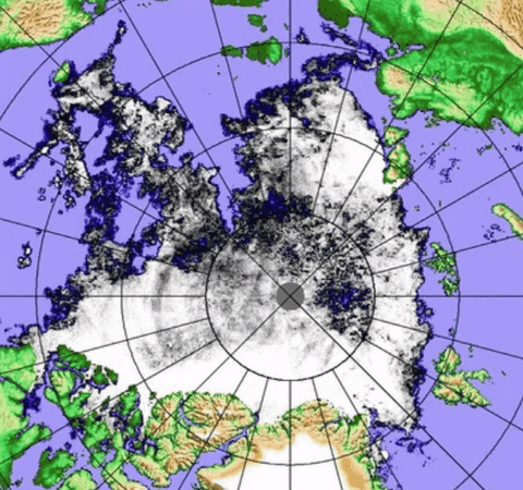
       The Cyclone Centre was about 85N 180W Longitude all day,   it expanded the open water there quite dramatically,  and this is not finished expanding:

      Most August 15 great lakes creations by smaller Low were "closed"  by wind movement away from the centre of the new Cyclone.  However there is far larger opening at 85 N than the day prior.


     The Cyclone seems to have affected the entire remaining sea ice pack:

     The Pack From Fram Strait to Banks Island Canada seems rotating counter clockwise.

     The rotation was also captured by AMSR2:

               The counterclockwise rotation of the entire pack has doomed the Wrangel Island sea ice panhandle much quicker, warmer sea water is about to seriously invade the Laptev sea region as well.
   Wherever the cyclone centre will remain steady,  there will be wider open water,  ECMWF seems to place this cyclone away from North Pole towards East Siberian Sea.   So it seems the  Pole area was spared,  for now,  from even more greater open water as never seen before.  WD August17,2016


Monday, August 15, 2016

Expanding North Pole Sea lakes, from a smaller Low prior to amalgamation with GAC 2016

     The expansion of open sea water at the North Pole has started by the older Low which deepened just before it merged prior to 18 utc with the GAC of summer 2016.  This expansion was expected,  but not quite like captured by AMSR2.
CMC Monday 15 00z Surface analysis of QS Quasi Stationary Low just South of the Pole 

The smaller Low 984 mb did a lot of expansion,  leaves to the imagination what the bigger one will do.    The proximity of the Pole has never had so much open water. wd August 15,2016 

Great movement Eastward by latest GAC and predecessors

   A small opening displaying Wrangel island ice bridge has been shrinking and compressing,  even
Goodbye Waves are interestingly bunched up against the ice edge,  either by recent past cyclones and in particular the latest one currently shaping up the icescape further.WDAug15,2016

Sea ice moved away from latest major Low pressure Centre


Latest  880 mb Cyclone was right over Laptev sea yesterday.  This is not a see through cyclone,  rather moderate to strong, we can only see its after effects once passed.  For better understanding of over sea ice floes interactions we must look at just prior sea ice movements.   
East of Franz Joseph Lands,  Sea Ice was mainly moving South.


    Notice near Ostrov Komsomolets likely Southwards moving ice but melting,  leaving a stable but badly shattered ice front with Goodbye Waves.
   In the wake of passage of new 980 mb cyclone centre, East of Ostrov Komsomolets reversal of flow direction , note the reduction in Goodbye Waves numbers and Northwards sea ice displacement.   August 15 winds are blowing  Southeastwards,  the main body of ice did not move in that direction,  but rather away from Low pressure centre. wdAugust15,2016

Saturday, August 13, 2016

Sliding Sea Ice; Recent sea water lakes near the North Pole made bigger by small Cyclone

~Preceding a mega lake at the Pole coming in a few days


   If Atmospheric pressure drops substantially,  sea level rises by not much,  up to 63 cm ,  but that should be enough to make even sea ice to slide downwards (tidal timing may make the sliding a bit interesting).  Gravity rules us all,  big and small, all things conform,  a recent small 988 mb Low now in the North Pole CAA-Greenland quadrant  is preceding a stronger one, but its effect on fragile looser sea ice left its imprint:

  This small see through 988 mb Low moving from East to West just South of the Pole (towards the Atlantic),  apparently innocent looking and minding its regular business, caused some damage to an already very fragile Central Arctic Basin unraveling, as I write,  sea ice:


August 11-12 AMSR2 Sequence enlarged and zoomed  show a disturbance in sea ice consolidation in a mere day,  especially enlargement of a sea water lakes (surrounded by sea ice).  This was done with a weak Low,  now we will see what a more than moderate 970 mb will do,  highly likely clearing the Pole as never seen before.  wdAugust13,2016

Friday, August 12, 2016

Scant near North Pole visuals; sea ice is badly broken up towards the Atlantic Front.

     For august 11,  we only have 2016,  2014 and 2013 with clear enough skies.  We know that 2016 is badly broken up on the North Atlantic quadrant of the Pole all the way to 88 North within the area of 00 Longitude  along the Trans Polar Stream.   2014 looked like solid consolidation in comparison. Much more broken with open sea water than  2013,  which always was an interesting year.    2016 has had great sea ice volume losses towards the Atlantic,  not necessarily showing well with the numbers. This area of sea ice has very serious implications with Central Arctic Basin consolidation,  if open water dilutes further this sea ice, it would mean more unstable situation leading for more massive losses or melting.   WDAug12,2016

Wednesday, August 10, 2016

Atlantic Front: substantial evidence of massive melting, 'goodbye' waves a plenty


All along the North Atlantic sea ice front,  about 1200 Kilometres long,  there are numerous new 'Goodbye' waves,  sure evidence of recent massive melting.  From Fram Strait,  to North of Spitsbergen to beyond Franz Josef lands,  as seen here in our roving NASA EOSDIS shots.  Although the newish extended sea ice front line position has recently expanded and appears  more or less stable, that is an illusion,  the sea ice melts just as fast as it touches warmer water.  The end result is a great loss of sea ice.  Assume Southwards sea ice movement a modest fluid 2 kilometres an hour ,  about 48 kilometres a day melt along apparently a steady front,  potentially 60,000 km2 a day loss is possible, without actual remote sensing detection. WDAugust10 2016.

Expansion and dilution at once, nature is playing games with our eyes

    While extent drops have recently been lesser,  the melt is just as strong:

Looking at JAXA results,  there has been an expansion of sea ice about 120,000 Km2,  on the North Atlantic front.  As reported here,   there is a great deal of daily melting along that front.  It can be readily identified by comparing when the front was quiet on July 26,  now look at Aug 9 map.  The entire front is battered by the melting (black broken ice zones),  but the flow continues Southwards, nevertheless  right into very warm sea water .   In the mean time,  the CAB is diluting more rapidly leading the way for further water expansion on the Pacific side of the North Pole, which is awfully close to wide open water areas.  Holistically speaking this melt is as bad as it got at this time of the season.  WD Aug7,2016

Sunday, August 7, 2016

Atlantic front great movement, super melting trap

  It did not take long for the real Arctic Ocean currents to be re-energized by favourable weather circulation,  there is a mini dipole at the other end of sea ice,  the Trans Polar Stream and main GAC Gyre appear almost full force.  As a result the Atlantic front, seen here, is expanding right into a trap of warm sea water.  With respect to Extent numbers,  they may seem less due to this vast expansion,    but robust they will be in the long run. wdAug7,2016

Individuals always melt away to darkness.


Fram Strait layered Goodbye waves join the ether of the sea.  Rapidly melting sea ice bounces about by collisions with others,  current and winds.  Goodbye waves seem curved and move more uniformly.  Like clouds a top the ocean.


                                                                     North Beaufort Sea. 
                                                     Man shatters the ice,  man looses face

Saturday, August 6, 2016

Massive number of "Goodbye" waves don't appear to register on JAXA

~Gyre centred Anticyclone rearranged flow circulation,  a pause in the big extent drops were to be,  however expected to surge again very soon


  Beaufort Sea July 22 August 5 AMSR2 result.   Massive area of 'Goodbye' waves didn't really show up on JAXA which is very interesting,  it rather means that they are essentially slush,  otherwise need be confirmed as such.

  The 'Goodbye' waves of August 4 and 5 set themselves apart from sea ice in many ways,  they are likely very thin slushy sea ice remnants (with  different chemistry?),  very thin because they move faster:

   Goodbye waves are generally faster than sea ice,  as a matter of distinction and practicality, essentially excellent example on how to measure sea ice volume.  Lighter objects floating on sea surface should be swifter, especially if the sea current goes different direction than the winds .   Sea ice moves South while Goodbye waves move West...    Place your mouse pointer on Aug 3 on any large sea ice pan, and determine the distance it travelled,  notice Goodbye waves move greater distances.  WD August 6,2016