Sunday, November 13, 2022

Ice on Mars equator, rather permafrost is everywhere on the red planet, Eh2r success story, bad news for another theory though.

 ~First suggested here 8 years ago,  permafrost was detectable without drilling on Mars.  

  On BBC recent report you can see meteorite crater confirm ice below ground:

https://www.youtube.com/watch?v=mg95vY10WSo

of a news article already almost a year old:

https://www.nytimes.com/2022/10/27/science/mars-meteorites-impacts-seismic.html


  .....   only confirms what EH2r research has discovered years ago:

https://eh2r.blogspot.com/2018/12/mars-insight-landing-spot-suggests-not.html

and here some 8 years ago:

https://eh2r.blogspot.com/2015/04/how-to-find-underground-frozen-water-on_25.html 

   It is gratifying to realize that no digging was needed by humans,   Mars surface is unlivable,  but by just watching, observing, something we refraction researchers do all the time. 

        Refraction studies do overlap or very closely resemble space time studies.   Of which Dark Matter or Dark Energy,  has a huge observation problem,  we don't see any hint of this huge content of theoretical mass.  Of which gravitational lensing,  ably explained by Einstein equations,  was confirmed by a solar eclipse.  Dark matter and energy has no such equivalent.   Consider all the trillion stars covering our sky,  the very minute exact position they maintain,  never changing position in the slightest,  despite the observer,  ie any telescope on earth or in space,  constantly moving through space.   Many stars should be slightly moving ever so now and then,  given the massive presence of Dark Matter.  

      In light of this EH2r Mars successful permafrost observation confirmation,  and the power and dominance of -observing- in science,  I don't give much time for the Dark Matter and Energy theories not to be considered plausible in the very least.....WD November 13, 2022.  


Saturday, September 3, 2022

Major shift in Sea Ocean Warming affecting everything


 ~Extreme warning of North Atlantic and Pacific part of,  or cause of ,  or part & cause of worldwide major climate shifts.

~  With some positive effects,  in part saving Arctic sea ice from utter decimation from the clouds they create.

~While negative consequences are documented in nearly daily extraordinary weather catastrophes

  I believe that this recent NOAA sst anomaly map explains it all.  A powerful La-Nina has had a hard time forming,  Arctic sea ice has had a hard time melting more as it should and the major pressure position patterns of global circulation,  all got flummoxed,  thrown out the comprehension window,  because we are now literally in a new climate age.  The one with near permanent warmer ocean regions.   As expected by EH2r projection, Arctic sea ice melt was greater than last year,  but nowhere near 2012 all time low extent minima.  As expected the AI weather outlooks came through,  nice for a change,  except for more rain in some regions,  this can be easily explained by warmer ocean sea surface temperatures,  not so easy to describe their location causations,  near permanent hot zones,  in the past usually with greater degree of variances:


  We remember variation of sea surface temperatures still during a recent warming time,  but in retrospect,  even in 2013 the emplacements of near permanent warming ocean regions were starting to be in place.  

     So now,  we must consider the new world weather order,  in the recent past, so much often eagerly denied by climate skeptics, surely presently not eating humble pie,  face saved by being in this age of many people choosing whom to believe,  rather than deciding or trying to find out what is really going on.  The images such as above,  need no rocket scientists to explain.  WD September 3,  2022


Sunday, June 26, 2022

STABLE; why the Cold Temperature North Pole matters

 ~At any given day of the year the CTNP is the prime circulation mover

~Where all weather systems spins around it

~When it is weak,  hardly anything moves

~This highlights the importance of Arctic sea ice,  the world would be dramatically different without it.

Look carefully at GOES 16 IR system movements,  over Cuba and Gulf of Mexico the weather seems steady for a period of 2 days,  however over Hudson Bay the weather systems move a little more consistently Eastwards.  The further away from the CTNP the slower the circulation,   therefore this weather, as forecasted beginning of May here on EH2r,  has come through as expected.

   Of which June 26 center of coldest air in the world is :


In the SE quadrant of Russia side of the North Pole,  as far from Florida as it gets,  this center wobbles
like a top on top of the world.   Influencing a temperature differential of far lesser  importance than during winter,  30 Centigrade less important while during winter this surface temperature difference is in excess of 60 C.   The weather systems slow move during summers,  giving either greater droughts or floods wherever the systems stagnate.  Absent sea ice the situation will be very much more severe,  Therefore a New World Weather order is rising,  not on Earth in millions of years,  when nothing much will move during summer,  causing the most severe extreme weather most humans may not desire.  So far sea ice is on schedule to be even less prominent,  slowly ,  summer by every next summer,  with the known consequences experienced all over the world.   WD June 26 2021


Sunday, June 12, 2022

Arctic Basin switchover time , about to happen very much on schedule

~Sea ice melt pond data is scarce,  but from long presence of Gyre Anticyclone it is assumed that there are many
~The effects of about to disappear circulation will be compounded by the effects of the coming one

CMC June 12 12 UTC surface prog:

 The sliding of the North Pole cyclone to the Arctic Basin Gyre location seems apt to be more permanent.  

The repositioning of the CTNP's poised to be at the Pole except for North Alaska,  which will get a North Pole Upper Air flow,  all indicate a near permanent Cold Temperature North Pole at the North Pole... 

Melt Ponds are a key factor determining the extent of melt damage done to sea ice early on the melt season.  They are hard to detect,  but this can be done indirectly:

   The black spots on on JAXA/ Bremen AMSR2 have likely melt ponds.  especially twinned with snow depth:
June 12 Climate Reanalyzer  snow depth seems to infer melt ponds pretty much along the coasts devoid of snow.   Although  radar PV photos are more nebulous:


June 10 North of Inuvik Beaufort sea nebulous cloud haze like image seem to indicate wide area of melt ponds.

     As far as sea ice is concerned,  the Low pressure over Arctic Ocean Gyre will shape the over all sea ice melt picture pretty much as I expect,  however slow sea ice extent seems to vanish is an illusion of sorts, the damage from the long presence of anticyclone allowing more sunshine was done,   any further massive storm will bring out near future fissures and exacerbate the melt process further especially late July.  WD June 12, 2022


Thursday, June 2, 2022

Rogue Vortice special Real effects

 ~As the pressure switchover looms,   the Polar Vortex fades in grandeur

~But as such many Rogue Vortices are created

~One May 31 Rogue gave some special effects


A Typical GOES satellite Infra Red picture loop,  May 31  2022 look at the center cloud circulation,  towards the South East,  nothing much to look at.  Until you look at the surface prog,  turns out the clouds are turning the wrong way:

Red X marks the spot,  the surface isobaric flow opposes the movement of clouds.  But the culprit is a Rogue Vortice from the ever shrinking Polar Vortex:

This Vortice is breaking away from the amorphous mangled Polar Vortex really centered in the Canadian Arctic Archipelago (CAA) , this Labrador Vortice  at center is -10 C quite cold for this time of the year.   Again from a sign that the North CAA Cold Temperature North Pole is not done yet:

June 2 2022 700 mb -26 C over Cornwallis Island ,  quite cold CTNP,   The switch over is not in yet,  still on sched,  because its so cold there, for about mid June.  Note the -10 C Labrador Vortice gone,  because Rogues don't last long but their effects give lasting memories.  WD June 3 2022


Saturday, May 21, 2022

EH2r Projection bang on, Arctic Basin Pressure switchover appears to be late

~Apparently not many are aware of this precision in predictions way in advance.
~But then again nobody uses the sun disk as a thermometer, hopefully in time this will change
~Eh2r predictions from multiple observations is looking really good,  in all aspects except for sea ice extent
~Nevertheless its exciting (for at least 30 followers)  when a deep Arctic circulation system is understood,  in essence Arctic temperatures dictate all weather movements Southwards 


18 UTC CMC surface prog May 6 (1025 mb High over Arctic Ocean Basin), 18 and 20, 2022,  look a likes.   to this projected May 1:


Eerily similar isn't it?      The main player is the giant C  in purple,  the Cold Temperature North Pole of the Polar Vortex.   Is cold,  but small,  but really cold:
  CMC 700 mb May 21 at 1200 UTC,  -30 C over Eureka,  Ellesmere Island Canada, wow that is cold but covering a small area.  However this fuels a stable surface High pressure over the Arctic basin,  but soon,  about mid June a dramatic pressure system switchover will occur,  a Low pressure will replace the Arctic Basin High pressure,  because,  Eureka will be very warm!  Last few years this projected switch came earlier.  The present steady circulation picture,  implies vaster areas of sea ice melt ponds,  spelling doom for it,  which seems to be fairing the usual bad,  but not a terrible melt pace yet,  again this will look much worse come late July,  worser than last few years.  Even if persistently cloudy,  and so goes the sea ice non recovery,  whereas climate is totally a key player.  The unstoppable Arctic warming continues even during LaNina period,  usually implying a cooling to take place,  but foiled again by Greenhouse gases.  WD May 21 2022


Monday, May 2, 2022

Very rare coincidence? EH2r projection in sync with most models.

 ~Sometimes AI gets it right

~EH2r projection just made in previous article really close to NOAA model even the Alaska bit


NOAA June July August  summer outlook,  amazingly in sync with EH2r summer 
projection,  in essence a wet SE USA and very hot Western USA,  along with little bit of Alaska.  
If there is no significant seasonal Arctic summer of old,  ie,  a much warmer Arctic,  there should be
very little circulation further South.  This implies the US desert weather to expand, also with practically Synoptic transport of moisture from the Gulf of Mexico, alleviation of super heating by reason of cloud cover.

   But not is all perfect with mega computers:


This AER May forecast misses the recent  CTNP ,  Cold Temperature North Pole hovering about the Canadian Arctic Archipelago and the one existing North of central Siberia,   nothing is perfect  for AI, almost  human,  but to contrast,  human intuition trumps millions of calculations per second,  almost every time.   WD May 2 2022


Sunday, May 1, 2022

Annual spring summer autumn circulation and weather projections deduced by mainly unorthodox means

 ~Amazing unusual past winter observations, from beginning to end

~Wild variances in Arctic climate was the main feature

~LaNina so mild not important as much as ENSO  trending warm or cold

~Unfamiliar sudden changes in Arctic weather patterns are rapidly becoming the norm


  The objective of this exercise is to see how much I understand weather dynamics in relation to geophysical observations lasting throughout the High Arctic autumn,  the long night and spring.   If I understand what happened well, I might have a very good idea what will become later.  


Prognosis

    A rapid prognosis of past autumn and winter is essential,  strangely ENSO pattern appears regular since summer 2020:

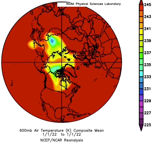
January 2021 mild La-Nina bottomed  likewise January 2022,  summer 21 was trending El-Nino but reversed course suddenly.  While from its peak warmth ENSO trended La-Nina just as fast as previous warming.  During that time in the Arctic ,  something very unusual happened,  it was very warm and more cloudy .  October 2021 was extremely, so much so ,  sea ice extent freeze-up rebound 
stalled greatly. Like clockwork,  ENSO trended El'Nino similar to exact period in 2021, 
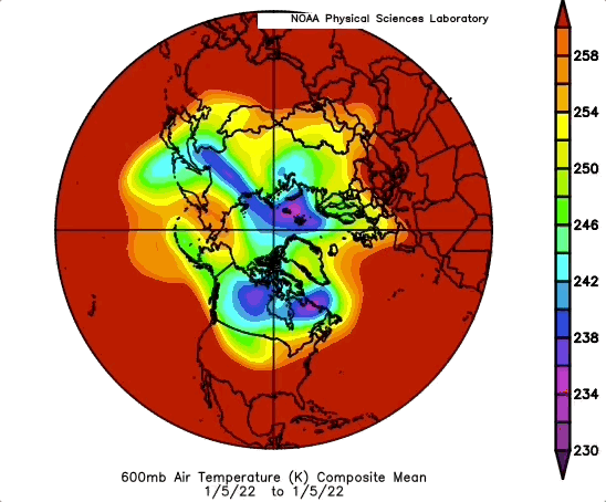
and eerily similar La-Nina trend struck,  however this times  La-Nina trend was in part responsible  for a very dramatic Arctic cooling,  because of cloud scarcity.  Keep in mind that winter 2021-22 was trending very warm, with super high tropopause heights,  along with adiabatic lapse rates similar to summer weather. When
the clouds cleared by mid March,  the tropopause dropped in altitude by 5 Km!  With more normal adiabatic lapse rates..   This sudden change in course of winter  a key feature, because sun disks were bigger in February than at end of April.  Reflecting the turn of events further, the Cold Temperature North Pole appeared strong for the first time of winter over the Canadian Arctic Archipelago, long did it last over Northern Siberia till February  Not only did this CCA coldest vortice in the Northern Hemisphere became steady but had more pronounced features than past several years,  from 2018 throughout 2020 the CTNP over the CAA was strong,  this year had the most prominent features.

With this in mind,  it may seem difficult to project ahead,  but it isn't,  mainly because refraction observations, not seen since 2016,  the strongest El-Nino year in history,  was surpassed in sun disk sizes until  La-Nina trending went full swing.  Not only that,  First Melt under the sea ice,  a feature detected by refraction means,  was strong and consistent from early April onwards,  equally similar to same time 2016,   suggesting very thin ice twinned with a lesser thinner snow cover. 

   In essence 2022 projection should be very similar to 2021, if forgetting the late winter colder atmosphere, the incredible warm start of winter from clouds, so many unusual cloudy days , which of course implies warmer weather.  This is known,; there is a smaller intense cooling at Spring start,  this cooling should trigger sea ice melting ponds,  because of the clear skies,  implying very few clouds, also means a dramatic upswing in sea ice surface snow melting from mid May onwards.  This late in winter super organized CTNP vortice is not going away quickly.  But,  will drag heat and moisture from the real weather maker rivaling ENSO, the North Pacific warm temperature blob,  this cloud and rain maker or booster is seriously changing the North American summer Arctic ,  which has been experiencing rain like in temperate zones. Even if  the coming Pacific extra clouds help shade sea ice from  strong sun rays,   rain can devastate sea ice almost just as much.  

Projections:

May 1 to about July 15   

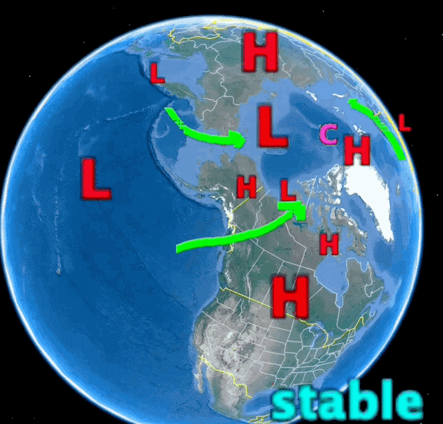
Circulation pattern largely like 2021  except 3 CTNP zones, major one  will hover over the Canadian Arctic Archipelago (Big C in purple).   Arctic Ocean basin High  pressure will last longer this year, because it exists from extreme cold conditions,  even if the CTNP is small in extent,  the Arctic Ocean Gyre driving anticyclone  is in a good place to last, because of weather dynamics.  The coldest air will be over the CAA until snow cover melts,  then,  a surprise awaits,  the permafrost didn't have a lot of cooling over the long night,  this means that sea ice will be the greater heat sink.    The Basin High will generate melting ponds likewise to 2008.  


July 15   To August 15


The modest La-Nina just past may have only added to the warming of the North Pacific blob in warm temperatures,  likewise it will help maintain a steady supply of rain to the NW Canadian Alaskan coast, especially clouds for the Canadian Arctic.   What is left of the Polar jet stream (in green) will eventually vanish for a while,  even when remnants of the jet is about, further Southwards weather will be stable in nature,  sluggish in movement,  prone to very hot in duration heat waves,  and  rainy periods for SE USA.  Emphasis on heat waves making the headlines  rather than rain though.   The Arctic Basin pressure system switchover,  although late,  will have a Cyclone loving cold ice, in the wake of a gyre driving anticyclone.  This cyclone favors less dumping of sea ice towards the Atlantic, but sea ice damage was already done, flushed out to Atlantic by the Gyre anticyclone lasting much longer than usual, also it helped adding thousands of extra ice surface water puddles,  making sea ice very vulnerable even if this steady in place cyclone shields most sun rays.    Like 2021,  the CTNP will hover at the North Pole , while Siberia will bake strongly again.  Swift changing weather pattern of NW Europe , will also slow to  crawl  as was summer 2021.  Not as fast moving weather systems, may be detrimental depending on what it does,  like extensive rainy periods causing damage.

August 15 to September 25

The return of a bit of a Polar jet stream will come as the sun lowers to elevations not so warming,  the Cold Anticyclone will be nearer Greenland as to hug what sea ice remains.  Siberian Cold Temperature North Pole will faintly appear, along with North Greenland and Ellesmere Island cold temperature vortice.  Note the vortices help form the north Pole anticyclone.  while this North Pole High grows,  a North Atlantic High will extend Southwards,  making the East North American coast vulnerable to hurricanes.  Most of sea ice will appear to melt suddenly  later than usual,  and the rebound freeze up will be very sluggish.

Arctic Sea ice minima

Estimated sea ice extent at minima,  sort of a mix result similar to 2007 and 2016.  The areas away from the steady hovering  mid summer gyre cyclone will suffer great ice loss especially North of central Siberia and North of Beaufort sea.  Due to earlier puddles and hot air advection from continental heat waves. Unlike  2021 Minima,  I'd expect more melting close to 2012 record,  primarily because Arctic lands will warm faster this year especially on the Canadian side of the Pole. WD May 1, 2022. 


Sunday, April 17, 2022

Voyage at Center of Cold Temperature North Pole, temperatures decreased as the rest of the Northern World warmed

~All the latest exciting discoveries were encapsulated in the first 2 weeks of April 2022

~  As the Northern Hemisphere warmed,  the Polar Vortex shrunk with extending outwards waves,  while the CTNP gradually returned to central Canadian Arctic Archipelago (CAA), making it deeply colder compared to 2 weeks prior.

~Vertical sun disks shrank accordingly,  but also had some expanded sun disks, meaning Cold Temperature North Poles have very small horizontal extents.  

~Absolutely astounding reversal of tropopause heights were noticed as well,  the tropopause at CTNP center can be as low as 5 km.


The Canadian Arctic  literally got colder as Spring progressed under the higher sun,  how exactly does this happen?  600 mb altitude closely represents the temperature of the entire troposphere.  The loop above show the only area not affected by southward waves of extended cold air,  the center of the PV, deepened in cooling,  where the atmosphere literally shrank in altitude as well,  the CAA tropopause in March was often at 10 km in altitude or higher,  by April 15 it was as low as 5.7 km (if not much lower).   Hence, a warming world can still have areas of deep cold temperatures.  In this latest event,  it was the circulation stability at CAA which enabled greater freezing temperatures.  Further South, the tip of Polar Vortex extended branches,  waves,   also caused multiple rogue vortices, which are weather entities capable of causing chaos,  simply because they cool substantially moisture rich air basking in the Sub Arctic.   At center of CTNP is like a voyage of exploration, where upon the observer remained steady.   It turns out. The center of a CTNP is not perfectly round like the eye of a hurricane,  but rather,  much like the Polar Vortex wavy shape,  rather a mini version,  I say that because vertical sun disks at CTNP center are irregular,  suggesting the horizontal core of CTNP column is amorphous,  which may have a deeper connection with the very shape of the Polar Vortex.   It was a unique privilege to be at at center of coldest air in the world,  it is not like many may imagine,  it was not cold, rather warmish, caused by the sensation calm surface winds do,  the CTNP was for a while at center of a low pressure,  which is fascinating, 
there was no other major detectable hint of it aside from sun disk anomalies.  WD April 17 2022


Sunday, April 3, 2022

A Rogue extremely cold Vortice just flew by, an example of the new winter look for decades to come

~Winter may be officially over,  but it said final goodbye in NE USA on March 28


~It was a Rogue Vortice,  very cold Cold Temperature North Pole  cut off from the Polar Vortex

~Expect more of these more often for many winters to come


   The geometry of winter has changed,  it has become thinner,  not bloated by darkness as it use to be.  In effect, winter still rages but for smaller areas, when so

the  vastly larger stable warmer air deepens the Cold Temperature North Pole(s),  not often at the North Pole,  but wherever it may be.  Sometimes very surprisingly, like a few days ago  as on March 28 over Michigan USA,  suffering again a cold blitz,  something special makes it there,  perhaps it’s the location tip of the elongated end of the Polar Vortex,  stretched out with favorable cooling weather  twinned with some cold air advection.  At any rate, being in late March,  such a low latitude CTNP has no chance of living long,  as it did so.  


However the geometry is of interest:


If you look carefully at State of  Michigan a cold zone formed by itself on the 26 of March.  
It soon joined the elongated Polar Vortex rapidly in a day,  there was a -31 C  700 mb temperature recorded there on the 28th.  NOAA daily composite does not show this because this -30 C 600 mb area was so small.   This rogue vortex moved rapidly North East and vanished afterwards.  Cold air can form as cold as the Arctic in temperate zones,  it depends on the weather. 

  The vast expanse of a fierce winter does not tend to create Rogue Vortices:

 
   The jet stream (green) does not shear away and create a rogue vortice while the Polar Vortex is intensely very wide and cold (blue).   That was occurring more often than not during not so long ago winters.   When it got cold, it stayed that way for prolonged periods.  Those were the days. 

     Recent winters were mostly warmer, not withstanding occasional periods of extreme cold weather.
Although never lasting long, characterized with hit and run blizzards followed by a lot of snow melting not long afterwards.   Geometry explains this,  a rogue vortice is easily created by narrower cold areas,  the jet stream bends along a lot more with the smaller collapsing in size state of winter.  Rogues have already shocked many people use to milder winter,  easily forgetting it was so until  a rogue hits their land.  The intensity of cold atmosphere  is related to how much stable time the low in altitude winter sun can not warm cloudless areas forcibly loosing long wave radiation,  heat to space.   The amorphous Polar Vortex as shown just above,   tends to cause circulation stalls as well, increasing the chance of one region loosing radiation to space continuously for weeks.  Hence strange reports of intense -40 C weather lasting long despite warmer weather everywhere else.  WD April 3,2022


Monday, March 21, 2022

Sun disks confirm anomalous Arctic warming

 ~Especially away from the Cold Temperature North Pole

~Presently in the extreme Northern Arctic lands of Ellesmere and North Siberia

      It took a while ,  more  extensive cloud cover slowed data acquisition, but today help  gathered more than 50 sun disk measurements having a remarkable 20% result of vertical sun disks being above all time highest decimal averages.  5% is considered normal random result,  indicating no warming or cooling of the atmosphere.  20% is 4 times above normal.  Not seen like this since 2010 and 2016.   Turns out there is a warming,  particularly over the Arctic Ocean, not coming as a surprise given the thinner sea ice: 

 https://www.theguardian.com/environment/2022/mar/21/extremes-of-40c-above-normal-whats-causing-extraordinary-heating-in-polar-regions

    Indeed , all time high temps coincide with increasing clouds and the perpetuation of North Atlantic and Pacific moisture well above the Arctic circle,  this evenings CMC 700 mb  chart shows where the heat was found to be,  not only today but for about the last 2 weeks.  

     In yellow is the area where sun disks were measured.  There was a significant CTNP off West central Greenland a few days ago,  now the CTNP hovers above Ellesmere Island.   The CTNP was much further South preceding West Greenland,  it had no staying power because of proximity to the North Atlantic,   CTNP migrated from Northern Quebec to West Greenland and finally central Ellesmere in about 8  days., all while flowing air from the Arctic Ocean basin southwards West of 90W degrees longitude.  In the not so distant past,  this would have meant a significant deep freeze in the same area in yellow.  Vertical sun disks are far more sensitive to the temperature of the entire atmosphere, than at any particular altitude.  At recent vernal equinoxes particularly 2018, 2019  and 20,  the CTNP was situated above the central Canadian Arctic Archipelago,  strongly shrinking vertical sun disks,  2022 equinox scene is different, more like 2017 and preceding years,  when sun disks were much expanded and representing the whole Arctic.  Measuring sun disks from center of CTNP gave a peculiar distorted view representing a stable center of extreme cold clear sky weather which was unique compared to past 17 years.  Colder air, albeit smaller in extent,  can subsist even when warming is almost overwhelming at every locations.
WD March 21 2022


Monday, March 7, 2022

CTNP moves; Siberia Canadian Arctic Archipelago back to Siberia

~ Winter 2021-2022 story to date,  CTNP shifts from Siberian dominance to the CAA and returning to Siberia.

~ Canadian Archipelago recent dominance is fading fast.

    The larger question throughout winter is always explaining the reason for Cold Temperature North Pole location at any given daily location.    Turns out 2021 early winter Siberian dominance may have been caused by Arctic Ocean having more open water,  hence more snow,  onsets early winter there, On Canadian side of Arctic, winter was delayed by incredible warming and less snow,  unusual considering last few years same periods.  

    Early Winter CTNP Siberia shifted gradually to Canada, largely because
it blew cold continental air across the just frozen Arctic Ocean,  in a river of cold air, clearly seen above and below.  This flow was unstoppable, the Siberian Polar Vortice assured this.  Eventually
the very moist flood giving Pacific North American flow of air was cut off by a huge stable Pacific High,  in part created by this flow.  This formed new anticyclones East of the Rockies which rapidly sent the Prairies in a deep freeze,  https://edmonton.ctvnews.ca/nastiest-deep-freeze-in-edmonton-in-over-a-half-century-1.5732278.  the stable cold clear reverse feedback cooling  air at 40 to 50 degrees North latitude over not so much snow covered land can go in a deep freeze fast because the sun is low in elevation and the nights are long in January.  This deep freeze eventually  joined the real area of very cold North American air in the CAA,  causing the first strong North American CTNP vortice,  dominating the Northern world.  However,  the incredible North Pacific blob of warm water temperature finally was returned by no less than the CAA CTNP,  another quasi permanent West to East circulation.   Now North America is facing a warming caused by the very center of coldest air apply placed about Hudson Strait.  As we can see below,  North America is about to warm substantially with a far weaker CTNP core vortice:

A weekly NOAA composite summary of 600 mb temperatures brings out what is to come.  Cold air may be stable next to a giant iceberg,  Greenland,  but is very vulnerable if pushed over the Atlantic, as it has been during the last few days, but before it vanishes,  the warmth of the Pacific has been dragged over much of North America.  This moist laden heat flow will eventually stall, and the last remnants of a weak winter may barely reach a wide area,  I'd expect a weak CAA CTNP vortice as already confirmed by sun shots,  giving about average differential refraction sun disks.  As the loop above shows, the extent of Polar Vortex  cold air is rather small,  guarantees  a shorter winter, early spring.  WD March 6 2022

Sunday, February 13, 2022

CTNP vortices avoiding Arctic Ocean sea ice , rapid warming of the Arctic transforms Polar Vortex morphology

 ~The speed of change is dramatic,  considering average warming by 1 C average use to take hundreds of years.  

~Arctic weather is morphing with respect to a warmer North Pole

   We look at recent CTNP vortices,  those coldest centers of the Polar Vortex,  at 600 mb pressure level, representing the temperature of the entire troposphere,  and find remarkable avoidance of the Arctic Ocean for having a Cold Temperature North Pole,  as surmised in previous articles,  they were interspersed, small, fleeting,  if any at all,  while similar over land at least lasting longer in duration or more stable:

CTNP's , the middle of coldest vortices found in the tropospheric Polar Vortex were remarkably bouncing all over the place in January 2022 finally settling into a major one over the Canadian Arctic Archipelago at January end.  But in the past.  CTNP's were not always Arctic Ocean shy:


Here we split the climate scenes made obvious in less than 30 years,  one in the 1970's and the other in last few years.  The contrast can't be more clear,  since 2007,  the Arctic Ocean seems to have been cleared of CTNP's,  while in late 70's it was 5 February 11's out of 6 which had CTNP presence,  rather than 1 out of 7 for 2007, 2016, 2018,2019 till 2022 same day.  The importance of taking a single day is not trivial,  since the area involved is huge, given same atmospheric chemistry, the odds are somewhere during the same day the temperatures would be similar.   Arctic Sea ice not as thick,  not as insulating from said but now warmer Ocean,  giving a different circulation pattern for the entire Northern Hemisphere,  which has not given pleasant or comfortable weather conditions in certain key locations of our planet.   WD Feb 12, 2022

Sunday, February 6, 2022

When coldest of winter starts from the South, the new climate normal

 ~An Arctic perspective use to portray cold winds from the NORTH

~Now cold atmospheres start from the South


Pay attention to the High Arctic weighted temperature of the entire troposphere.  At beginning of January till mid month the coldest air was further South,  then after the Cold Temperature North Poles grew in size,  the coldest temperatures finally settled in the High Arctic.  This climate shift is recent.  Basically implies a warmer Arctic,  on land especially over thinner sea ice.  Still implying the bulge of winter moved Northwards in several locations.  Over the oceans and virtually on every part of the continents,  whereas winter of old still exists but for much shorter time periods.  On the North American side,  the CTNP settling over the Eastern High Arctic give more often than not the warm winter periods of late.    However the less expansive Cold Temperature Vortice centers on each continents make for dramatic weather changes,  which make the news because these weather events are usually out of time and place. WD Feb 6 2022


Friday, January 28, 2022

Don't look UP .... North....... Arctic sea ice in dire straits (literally)

 ~Ridging sea ice against the Canadian Arctic Archipelago hardly exists!

   These are strange days, when denialists and a few microphone Youtube presenters sway large segments of our population to believe in fantasy impressions of reality,  even when evidence,  not little bit of evidence, massive sways of archives occupy computer memory banks, instead of human minds.  

  To help up a few hesitant deniers,  and to encourage them to do their own exploration, hopefully backed the writings of giants (found in any good science book) .  Here is the Canadian Arctic Archipelago,  just NW  of its center,  January 23 and below this for good measure 26 ,  2022,  


    January 23 Polarview picture,  the top one,  looks very distressing,  January 26 ,  same area,  shows some freezing,  which should be extremely strong in Polar darkness,  it doesn't seem so here.  For those who don't know about the Canadian Arctic Archipelago (ie CAA),  I am not surprised,  TV maps rarely depict them correctly:


The placement of 2021/22 on this weather map,  is where the sea ice pictures above come from.   The CAA is portrayed the usual way here,  as something to type over.  Actually its a fairly good TV weather map compared to most.    At any rate,  there was and  is (to a lesser extent) a tidal ridging of sea ice ,  going back millions of years, from the Arctic Ocean basin (the Arctic Ocean) towards the Canadian Arctic Archipelago NW shore,  this ridging and compaction, was, once upon a time ,  intense:


Same location as pictures above, HRPT likely USSR  Meteor,  but can be NOAA,  circa 1989, January 4.  The coastal Arctic sea ice day, was solidly frozen, marked by "tidal' leads, often frozen in a day, looking like hair strands or river channels.  On occasion, as on this day,  a High pressure, massive, heavy, opened up the very thick consolidated sea ice. But water opening never lasted longer than a few days, recognizable by their grey-ish appearance (new ice and fresh snow cover), the big black lead above  had a short lifespan.  Again for good measure we have another archive  picture:


     19 days later,  the huge High  pressure lead can't be recognized,  it almost totally vanished,  but newer "tidal" leads can be seen.     They are created  and destroyed, vanished  and faded daily.  The difference here,  between 1989 and 2022 is obvious,  there is less thick sea ice ridging against the CAA shores,  the 2022 shots demonstrate a summer sea ice configuration,  looser pack,  significantly thinner,  with a lot more open water.  Compare again with a modern same resolution as 1989 NOAA HRPT photo Jan 27 2022:


        Arctic long night sea ice is barely recognizable a mere 33 years later.WD Jan 28 2022

Monday, January 17, 2022

Great Temperate zone in origin FREEZING blast, whatever happened to the Arctic blast? I wonder.....


Last I looked , 65 degrees North latitude was the sub-Arctic,  where most of the cooling action seems to have been created in between January 5 and 10 2022,  but again, the greatest cooling occurred nearly in the temperate North American  zone.    In such the new weather Climate takes shape,  tropospheric Polar Vortex Cold Temperature North Pole vortices form here and there, appear to move rapidly,   or  form and disappear just as quickly,  at the same time, with very steady cyclones and jet stream positions.  And such are the days of transition,  just prior to perineal Arctic sea ice soon becoming seasonal. WD January 17, 2022

Wednesday, January 12, 2022

Shrinking of winter, one year at the time

~The bitter cold "Arctic Blast" isn't as big as it use to be

~Visual proof of Global warming very apparent,  especially when La-Nina periods look like El-Nino


          Winter 2021-22 started small:

In fact millions of square kilometers smaller than 1977,  2016 very powerful El-Nino warming is comparable to modest La-Ninas during  2020 and 2021 as well,  astounding if you think of it.  The only quadrant from North Pole apparently not so much changed since 77 is the Russian side.  Temperatures at 600 mb are more influenced by greenhouse gases and surface temperatures than the stratosphere,  which tends to cool when the troposphere warms.  600 mb is also the closest pressure level to the density weighted temperature (DWT)  of the entire troposphere.  


Latest December mean 600 mb winter temperatures have equally shrunken in extent quite visibly.  In particular in the Canadian Arctic, North Pacific and Atlantic.  2021-22 loss of the Canadian Arctic frost continental wide 'bite" was particularly felt on the Eastern North American coast.  Notably because the extent of cold Polar vortex centers,  highly circulating influential vortices,  are smaller.  It does not mean that smaller vortices are warmer,  they can be just as cold as ever or even more deeply cold.   Cold Temperature North Poles of smaller extent are equally mobile and can navigate the Globe rapidly,  easily making people forget the warm winter they enjoyed so far.  Again it is quite obvious that the new world climate winter order will be dominated by Siberia.  Implying dramatic changes not experienced by humans in many parts of the world.  In particular NW Europe,  the Canadian Archipelago CTNP vortice has huge implications if absent.  Namely the Gulf Stream cyclones can turn Westwards instead of Northeastwards towards Ireland and the UK.  Alaska benefited extreme warming for lack of the Canadian Archipelago bulge as well.  The other large unknown is what will this do to the Gulf Stream itself,  in the long run a significant Atmospheric circulation change also gets to influence Ocean currents.  WD Jan12 2021