Sunday, October 22, 2017

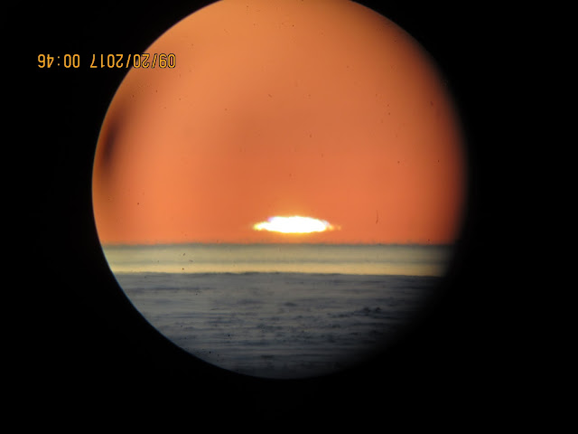
New signal of a warming Arctic Ocean: the Green flash green sea

~Never observed literal greening of the NW passage
~The likely cause was a much warmer top of sea opposing a quick refreeze caused by light winds...

    30 Years ago Arctic top of sea refreezes,  particularly here,  75 North 94.5 West,  were often in early September,   at the first chance of light winds,  then after October was bitterly colder,  fostering the onset of winter to last till June.  During these older days, the boating season was about 3 to 8 weeks long,  since on shore fast ice came so early  and the sea ice broke up as late as August.  Now this season is almost always more than 16 weeks.

    Freeze-up 2017 was no different than any other except it came late,  a feature of the post 1998 sea ice period.  Grey ice comes almost always when there is a calming of winds during clear air events.
There is yearly one natural cloudy season for the High Arctic from Mid April to Mid September,   this season has changed recently,  it comes often mid April  as usual,  but became more intense,  with heavier precipitation for months.  Post 1998,  this cloudy season stretched often till end of October,  making freeze-up much more difficult,  another component is the -11 degrees C mark,  which is the most observed temperature which causes grey ice.  Although sea ice freezes at -1.8 C,  it takes much colder air temperatures to counter balance the net thermal top of sea state not at all at its freezing point.  If there is a warming of sea water it does not mean that freeze-up will always come later, it is a matter of the right circumstances.

      With right conditions:  clear skies, calm seas, temperature nearing -11 C;   freezing may occur.  So it was  September 19 2017,   the winds were quite slow less than 5 knots,  the sky was clear (an unusual autumnal feature),   some freezing started:

      Never seen before "green flash green" sea,  a refraction effect not entirely understood.    Definitely new,  the green may be a mix between horizon sky and the natural sea water blue we usually observe at all sunsets. 

    Past blue seas at sunset examples abound,  I picked a few:

    Practically all open water sea sunsets are dark blue (grey when cloudy),  even with exact 2017 conditions.   The orange horizon of 2012 is identical to 2017,  yet with dark blue seas.


   September 19 2017 sunset occurred mid air,  signifying thermal inversions,  note the lack of reflection of direct sunlight over the sea, there is a band of thermal layers,  called ducts,  intensely stable temperature wise.  This is done with clear air, light winds and in this case,  the fresh formation of a very thin layer of sea ice.  Right above the newly formed ice the air was automatically colder,  higher up near surface air was warned by sea water before the ice showed up.   Latent heat of fusion also released some heat which ascended higher by buoyancy,

   But this new very thin ice did not last,  temperatures warmed to the -3 to -5 C range on September 20 and 21, come the 22nd.  All new sea ice was gone.   Again,  worth to note that sea ice may melt with surface temperatures above -11 C, 


   This  "green flash green" ocean was a never seen before event,  it showed up roughly 40 minutes after the blue ocean with the sun above the horizon at about 5 degrees C elevation  (first blue sea horizon picture).   With the lower sun,  the orange horizon came about, implying very clean air conditions.  The distant ship seen in dark shade hues was captured upright,  but betrays the very complex layering just below.   One of which demonstrated a Wegener blank strip,  a relatively rare optical event,  implying a steep thermal inversion,  a blank strip is an optical construct consisting of a very long thermal duct,  very distant having no light from above or under which can penetrate it,  therefore the darkened layer black impression you can particularly see in the un-zoomed picture with the green sea.

   Implications:

     The 'never seen before' aspect of this event,   is a major discovery,  the reasons for the greening of the sea horizon,  needs to be modeled,  in other words , replicated by computer animations.  Historical GRIB data should also have steep inversions above the sea surface below 46 meters ASL. 

     This is a splendid example of atmospheric optics readily available to verify state of the art atmospheric computer models.  If the models do not have inversions below 46 ASL,  they need be improved.  WD October 24 2017.   


Sunday, October 8, 2017

What was Hurricane Maria pushes the jet stream North, take 2

~ A very fascinating feature of post hurricane cyclones was captured again.

2016 Hurricane Nicole turned extra tropical Cyclone peculiar feature  (explained here),  may seem ancient or distant,  given the comparatively busy 2017 season.  But there were much fewer hurricanes over a longer period,  from 2006 to 2015,  despite much warmer oceans,  in fact the conclusion that there would be less frequent but more powerful hurricanes was correct (Emmanuel),   not like Typhoons,  which are storms from a different huge Pacific Ocean playing field. 

Note the regular feature of Jet stream (drawn green)  on this CMC Oct 7, 2017 1800 UTC surface analysis chart.   It contours the Southern part of Cyclones,  this is a normal for the Polar jet stream ,  except for where a peculiar  Cyclone  near south east Greenland (ex hurricane Maria) seems to push the jet to the Northwards,  the jet contours the Cyclone very unusually.  It seems being more like an anticyclone .WD Oct7, 2017

Thursday, September 7, 2017

The Very good work of MIT's Professor Kerry Emmanuel

~ "A-new-study-says-hurricanes-will-get-stronger-and-more-frequent-thanks-to-climate-change"

~  Contrary to fringe media gossipers bent on lying and ignorance,  science at times can be prophetic;
less frequent but very strong  hurricanes are at play.  As published in a journal many years ago (since at least 2005).  

First system formed 

June 8, 2005 

Last system dissipated 

January 6, 2006

(record latest, tied with 1954
Strongest storm Name 

Wilma (Most intense hurricane in the Atlantic basin) 

• Maximum winds 

185 mph (295 km/h)

(1-minute sustained) 

• Lowest pressure 

882 mbar (hPa; 26.05 inHg

Seasonal statistics 

Total depressions 

31 (record high) 

Total storms 

28 (record high) 

Hurricanes 

15 (record high) 

Major hurricanes (Cat. 3+

7 (record high, tied with 1961

Total fatalities 

3,913 total 

Total damage 

$158.9 billion (2005 USD)
(Costliest tropical cyclone season on record) 


First system formed 

April 19, 2017 

Last system dissipated 

Season ongoing 

Strongest storm Name 


• Maximum winds 

185 mph (295 km/h) (1-minute sustained) 

• Lowest pressure 

914 mbar (hPa; 26.99 inHg

Seasonal statistics 

Total depressions 

12 

Total storms 

11 

Hurricanes 


Major hurricanes (Cat. 3+

3

Total fatalities 

91 total 

Total damage 

> $70 billion (2017 USD)
     The past 12 years were not exactly busy ones for hurricanes,  quite unlike typhoons.  
the South Atlantic has its own weather factors going,  namely its smaller size than the Pacific, ENSO influence and the effects of dust from the Sahara desert.  The latter was observed in late July falling over South Texas.   Perhaps the Saharan dust plume relinquished in later August letting the hurricanes form without dust impediments:

   March 2017 Saharan dust plume North Africa is seen to the upper right.  It makes a great deal of sense that dust may simply inhibit hurricane development,  also likely a warmer planet, in turn Sahara,  will diminish the number of hurricanes forming.  Hence the likely further warming  of "uncooled" South Atlantic sea water,  as it is known,  that hurricanes mix the underlying lower cooler layer of sea water with the very warm surface sea under its path.   The further warmed more stable  sea water may give incredibly stronger hurricanes whenever the conditions are ripe.  

    The good news ,  certainly needed,  is that the last Arctic cell of massively cold air exists at this time in the Greenland-Ellesmere-Devon-North Baffin region, is as strong as can be according to current High Arctic vertical sun disk measurements,  quite compressed, similar to March even though the density weighted temperatures are 10 degrees warmer.  The mid to higher upper atmosphere is much cooler because there is less clouds than over the rest of the Arctic.   This cooling positions the jet stream and or circulation directly further South towards where the hurricanes are.   This is a better scenario than what happened with Harvey in Texas. WD September 7, 2017

Monday, August 28, 2017

Weakened Global Circulation consequences; hurricane Harvey has nowhere to go


~ NYTimes sums it up: “This event is unprecedented & all impacts are unknown & beyond anything experienced,” the federal service said on Twitter on Sunday."

~ Not only isolated to Americans but To India and Bangladesh seasonal monsoons: "Modi said the floods had wreaked havoc on a massive scale, adding that altered weather cycles linked to climate change were having a big negative impact. He announced 200,000 rupees’ compensation (£2,374) to the families of those killed in the deluge and 50,000 rupees to those seriously injured."

~ Japan was not spared https://www.japantimes.co.jp/news/2017/08/23/national/high-pressure-boots-central-tokyo-rain-system-21-day-wet-stretch/#.WaSNatOGNTY" Not only for only Tokyo area.

~Europe had mostly very hot weather as predicted:

http://www.euronews.com/2017/08/07/heatwave-lucifer-testing-southern-europe

~ A huge Swiss Mountain Landslide came with the heat and melted permafrost:
Permafrost thaw

"The reason is that the high mountains are not as cold as they once were. Marcia Phillips, a permafrost researcher with Switzerland's Federal Institute for Snow and Avalanche Research, has been analysing temperatures all over the Alps."


Hurricane stalls are not necessarily very rare, but Global Circulation not moving normally has consequences all over the world.

If you weaken the source of Arctic cold air creating the familiar Global Wind patterns , a more stagnant circulation ensues, as such predicted in April:

  If you shrink the mass of cold ice to a much smaller surface area, circulation stalls would occur all over the world, as they have. We remember numerous Hurricanes such as Katrina, Frederic and others hitting ground but not lasting long over the continent, swiftly brushed away mainly to the North North East.


The remarkable projection right above this CMC August 28 2017 1800 UTC surface analysis, placed the main Highs and Lows pretty much where they happened today.
It is not a coincidence, but rather a correct interpretation of the future. We look at further details with IR animation:


What I noticed , is particularly the Western Part of the US, the Southward flow of clouds, Hurricane Harvey more or less stalled with a very small North Eastwards drift. Northern Canada has the flow which happens most times over the SE USA.

These are unfamiliar weather circulation patterns, which of course were born from the planet consistently warming. The extra rain pretty much happening on many planetary locations is due to the remnant of a strong just past El-Nino seeding combined with greater evaporation rates boosted by this warming. WD August 28, 2017


Saturday, June 24, 2017

Almost everything predicted for 2017 is turning out

http://eh2r.blogspot.ca/2017/05/annual-bit-late-2017-northern.html

  The linked above annual spring projection of important weather events is doing just fine.

" The Okanagan valley BC will be hot and dry at first then turn quite wet, Midwest North America will be mostly dry and very hot"

  My favorite prediction written when the Okanagan was on the verge of major flooding due to extensive winter snowfall and spring rain.  The "theory of persistence"  would have made this catastrophe possible,  but the Northern in provenance atmospheric circulation saved the valley (as projected).  The moist Spring turned to above Normal temperatures:
 https://www.esrl.noaa.gov/psd/map/images/rnl/sfctmpmer_30a.rnl.html

Western European Heat wave,   check : http://www.france24.com/en/20170622-paris-pollution-peak-driving-ban-europe-heat-wave-longon-portugal

Less American Tornadoes,
check :http://www.spc.noaa.gov/climo/online/monthly/newm.html

    Note the earlier more intense period of tornadoes,  preceding lesser numbers when there should be more.  The prediction was about this period after mid April.

ENSO to Neutral, 

 check: http://www.ospo.noaa.gov/data/sst/anomaly/2017/anomnight.6.22.2017.gif

   Note the residual cloud seeding from El-Nino 2015-16 replenished water to many areas of the Earth stricken by drought.  

"I would expect record number of melt Ponds -late- from all that thick snow cover. This will accelerate the melt rapidly, numerous melt ponds will signal the start of very rapid melting, after seemingly sluggish melt daily rates interspersed with at times great variations caused by the lack of sea ice consolidation."

   This is indeed happening.


"when this snow disappears in June, there will be huge water ponds, the ice will vanish extremely quickly then after."

   Needless to say,  let us use Barrow Strait Canada with picture animations:


  In 2016 Barrow Strait had significant snow cover over sea ice,  the Strait cleared of ice late June:

http://eh2r.blogspot.ca/2016/07/sea-ice-affected-by-lot-of-snow-end.html

   Winter 2017 had significantly more snowfall especially at end of the long night:

  Down the Baffin Bay drain!   One month earlier than last year.  The sea ice did not stand a chance to withstand even seasonal weather,  because it was so thinned by a very thick snow cover during long Arctic night accretion.  The same is expected to happen wherever there was more snow cover over sea ice,  which may be pretty much the entire pack.  

       So now we wait Barrow sea ice disintegration to hit the larger remaining ice pack.   WD June 24 2017

Tuesday, May 30, 2017

Fram Strait channel doubles, North Nares Strait has no Greenland stable sea ice shelf at all

We notice the usual late May early June "spring break" especially North of Ellesmere Island, the Big Lead reappeared along with many Northwestwards lateral fractures. The entire pack turning clockwise is a common feature at this period of year.  What is very unusual is is North of Greenland total collapse and disintegration of its perineal stable sea ice shelf,  which in the past reduced the flow of  ice through Nares Strait substantially.  In history,  the marking feature North of Nares was a circular opening of water surrounded by stable ice:
  A few years ago, 2 weeks later,  as seen through clouds,  North of Nares circular current and broken ice zone,  was mainly caused by stable ice,  now gone.  It can only mean more substantial sea ice lost, the steady ice shelf barrage is gone.   WD May 30,2017

Sunday, May 21, 2017

North of Nares Strait region sea ice, once steady stable perineal, now thin unstable seasonal

   May 21 NASA EOSDIS captures for 2017, 2013 and 2015,  May 21 selection was chosen as the earliest date comparable,   extensive cloud cover forced the choosing of  later dates were picked for 3 other pictures:  2016 June 12;  2014 May 27 and June 15 for 2012.  Despite the much later dates sea ice was never for the worse compared to May 21 2017,  broken and smashed up,  is true to present days weakest formation of very thin tenuous sea ice.  As the NASA clips suggests, it was very recently not always this fragile North of Nares Strait,  despite a near permanent Gyre and tidal current,  2012 ice looked substantially thicker and stronger a month later.   This year to year animation gives the impression of a progressively continuous sea ice deterioration.   In the late 80's this ice sheet especially next to Greenland  was rock steady year round with only the current breaking it up at Northern entrance of Nares.  The broken up appearance of sea ice in 2017 demonstrates the total collapse of the steady but important thin sea ice shelves (3 to 5 meters).  WD May 21,2017