
Sunday, August 28, 2016
Canadian Side usually ultra dense sea ice observed loose up to 89.5N
Wrangel Island ice bridge methodically becoming no more.
~If it all melts, 2012 extent record will be seriously challenged or exceeded
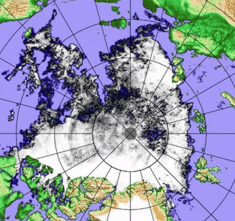
Within last 4 days, the Wrangel Island ice bridge has lost about half of its extent, at this rate it should be all gone within a week, since the water surface to ice ratio increases every day:

Once the middle of Wrangel Island ice bridge to Pole becomes water, likely in a few days if not tomorrow, the melting will accelerate. Comparing to 2012 is of interest:

There are huge differences between the icescape of August 27, 2016 and same day 2012. 2012 had an ice bridge to Wrangel but disappeared earlier, North of Laptev sea ice was only present above 80 N, the Atlantic front was more to the North. However 2016 has a deeper towards the North Pole sea water bite and has incredible CAB lower density sea ice areas :
 The over all up to date review suggests 2016 capable of surpassing 2012 in its own way. Melt years are rarely alike, even one following another. What makes 2016 apart, is that it happened significantly without a prolonged Arctic Dipole, in other words, without a great deal of summer insolation (and its cooler in summer when cloudy, even in the Arctic). This was a prerequisite proving that warming Global Temperatures need not have favourable weather conditions to devastate the existence of Arctic Sea ice. WD August 28,2016
Within last 4 days, the Wrangel Island ice bridge has lost about half of its extent, at this rate it should be all gone within a week, since the water surface to ice ratio increases every day:

Once the middle of Wrangel Island ice bridge to Pole becomes water, likely in a few days if not tomorrow, the melting will accelerate. Comparing to 2012 is of interest:

There are huge differences between the icescape of August 27, 2016 and same day 2012. 2012 had an ice bridge to Wrangel but disappeared earlier, North of Laptev sea ice was only present above 80 N, the Atlantic front was more to the North. However 2016 has a deeper towards the North Pole sea water bite and has incredible CAB lower density sea ice areas :

Friday, August 26, 2016
Trans Polar Stream, first time so wet in history, is simply huge, it may cause a fluid mix accelerating flushing to the warm North Atlantic.


Fram Strait is rapidly bulging Southwards with sea ice, this means that the Open Trans Polar Stream may reach the Strait, with 0 to +7 C sea surface temperatures. Notice Goodbye waves between Greenland and Spitsbergen Isles, they expanded from August 23 to 25 as well, a sure indication of rapid melting along with the arrival of new sea ice. If the Trans Polar Stream open zone reaches Fram Strait, it would mean a much more fluid flow of sea ice to the North Atlantic.

Thursday, August 25, 2016
The Trans Polar Stream is becoming like a sea water river carrying loose sea ice to the Atlantic

Wednesday, August 24, 2016
Huge sea ice area is on the Razors edge, between water and survival


There is a sea ice lake, the size of Lake Superior, 85N 135E, the remnant of GAC3 again dispersing ice at Centre of this Cyclone. The Wrangel Island ice bridge seems on the verge of total collapse. The other, towards Laptev sea, only has less than 1/3 of its pack apparently solid. The Atlantic Front appears to be moving North. There is significant extent numbers consisting of 80% or more of seawater, which would count as 100% sea ice.


Tuesday, August 23, 2016
Goodbye waves lack of geometric continuity, drastically different than melting Fram Strait sea ice

Monday, August 22, 2016
North Pole Sea ice: what we can see 2016 is bad, 2013 visually worse, but 2016 is it


Compaction vs scattering, sea ice movement favours some extent gains on the leeward side until spreading gets water to be prominent.
Sunday, August 21, 2016
Towards the left, captures file.
~"to the right" of wind direction- -+ sea ice dispersion is not easily captured.
~ here we have "to the left" compaction by GAC2
 Despite clouds large ice pans were moving to the centre of GAC2 2016. Winds go from top to bottom of frame. Located just NW of Banks Island Canada, Sea ice is converging towards centre of the Cyclone. WDAugust21,2016
~ here we have "to the left" compaction by GAC2

Saturday, August 20, 2016
2016 signature characteristic: Sea ice floes not moving very fast

Subscribe to:
Posts (Atom)