Monday, August 22, 2016
Compaction vs scattering, sea ice movement favours some extent gains on the leeward side until spreading gets water to be prominent.
Sunday, August 21, 2016
Towards the left, captures file.
~"to the right" of wind direction- -+ sea ice dispersion is not easily captured.
~ here we have "to the left" compaction by GAC2
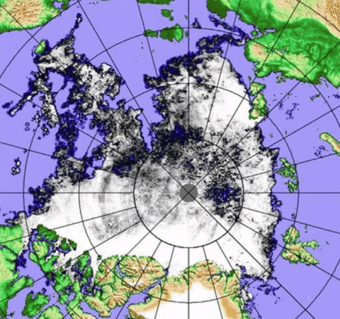
 Despite clouds large ice pans were moving to the centre of GAC2 2016. Winds go from top to bottom of frame. Located just NW of Banks Island Canada, Sea ice is converging towards centre of the Cyclone. WDAugust21,2016
~ here we have "to the left" compaction by GAC2

Saturday, August 20, 2016
2016 signature characteristic: Sea ice floes not moving very fast

Friday, August 19, 2016
Challenge to #1 minima, Sea Water conquering by dividing, fraying sea ice at the edges

Thursday, August 18, 2016
2nd day GAC, North Pole situation looks more open than ever
~Sea ice rotation "to the right" of winds, does not show up so well, scattering seems more isobaric
~ Melt rates vary in steps associated with Low pressure movement.


~ Melt rates vary in steps associated with Low pressure movement.
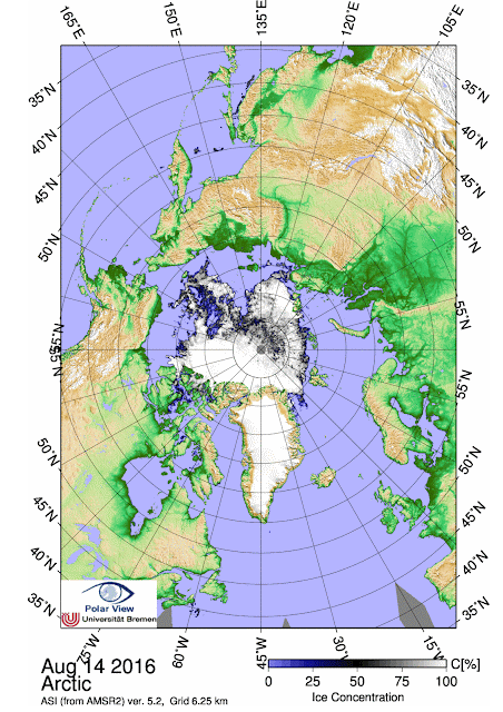
CMC GAC yesterday august 16 at 18 UTC
CMC August 17 18 UTC surface analysis. 981 mb situated 82N 150E not moving Southwards anymore from this time , at 00 UTC the centre was 82N 155E, 983 mb. This means that a new batch of sea ice was broken up further and or at different locations since yesterday. Note the isobars, and look at the rotation of the entire sea ice pack carefully:

JAXA Map Clearly shows very little outward dispersions, but very much sea ice movement following Isobaric lines more closely. The centre of the Cyclone stayed long enough at 86N to cause extensive water zone not readily filling up with scattered ice. You can even notice the isobaric lines etched in sea ice just South of the Pole towards Alaska and Bering Strait. The new Low pressure centre has dragged a new batch of sea ice along the Ostrov Komsomolets Eastern ice bridge shore to cover open water, this accounts for a reduction in extent daily drop to 73,373 km2 (3rd greatest melt for aug 17 since 2002). Note the great scattering of sea ice along Wrangel Island 'pan handle' Eastern shores, surely will give great extent drops in the coming days. The rotation of the entire pack also affects the Atlantic sea ice front, bringing sea ice a top exposed open water. Finally if the Trans Polar Stream has a chance to resume, there will be a lot of open water at the North Pole come this minima. WD August 18,2016
Tuesday, August 16, 2016
1st GAC summer 2016 preliminary effects
~ Following scattering slow down, today's extent drop is the largest in August 16 history (2002-2016) 109,341 km2.
~ Rotation of entire sea ice pack appears to be counterclockwise.
~ Low pressure centre still not at the Pole, most of yesterdays sea lakes vanished by strong winds.
~ Cyclone centre expanded near adjoining sea water areas.
The Cyclone Centre was about 85N 180W Longitude all day, it expanded the open water there quite dramatically, and this is not finished expanding:
 Most August 15 great lakes creations by smaller Low were "closed" by wind movement away from the centre of the new Cyclone. However there is far larger opening at 85 N than the day prior.
The Cyclone seems to have affected the entire remaining sea ice pack:
 The Pack From Fram Strait to Banks Island Canada seems rotating counter clockwise.
The rotation was also captured by AMSR2:
 The counterclockwise rotation of the entire pack has doomed the Wrangel Island sea ice panhandle much quicker, warmer sea water is about to seriously invade the Laptev sea region as well.
Wherever the cyclone centre will remain steady, there will be wider open water, ECMWF seems to place this cyclone away from North Pole towards East Siberian Sea. So it seems the Pole area was spared, for now, from even more greater open water as never seen before. WD August17,2016
~ Rotation of entire sea ice pack appears to be counterclockwise.
~ Low pressure centre still not at the Pole, most of yesterdays sea lakes vanished by strong winds.
~ Cyclone centre expanded near adjoining sea water areas.
The Cyclone Centre was about 85N 180W Longitude all day, it expanded the open water there quite dramatically, and this is not finished expanding:

The Cyclone seems to have affected the entire remaining sea ice pack:

The rotation was also captured by AMSR2:

Wherever the cyclone centre will remain steady, there will be wider open water, ECMWF seems to place this cyclone away from North Pole towards East Siberian Sea. So it seems the Pole area was spared, for now, from even more greater open water as never seen before. WD August17,2016
Monday, August 15, 2016
Expanding North Pole Sea lakes, from a smaller Low prior to amalgamation with GAC 2016
The expansion of open sea water at the North Pole has started by the older Low which deepened just before it merged prior to 18 utc with the GAC of summer 2016. This expansion was expected, but not quite like captured by AMSR2.


CMC Monday 15 00z Surface analysis of QS Quasi Stationary Low just South of the Pole

The smaller Low 984 mb did a lot of expansion, leaves to the imagination what the bigger one will do. The proximity of the Pole has never had so much open water. wd August 15,2016
Great movement Eastward by latest GAC and predecessors

Goodbye Waves are interestingly bunched up against the ice edge, either by recent past cyclones and in particular the latest one currently shaping up the icescape further.WDAug15,2016
Sea ice moved away from latest major Low pressure Centre
Latest 880 mb Cyclone was right over Laptev sea yesterday. This is not a see through cyclone, rather moderate to strong, we can only see its after effects once passed. For better understanding of over sea ice floes interactions we must look at just prior sea ice movements.

East of Franz Joseph Lands, Sea Ice was mainly moving South.


Saturday, August 13, 2016
Sliding Sea Ice; Recent sea water lakes near the North Pole made bigger by small Cyclone
~Preceding a mega lake at the Pole coming in a few days
If Atmospheric pressure drops substantially, sea level rises by not much, up to 63 cm , but that should be enough to make even sea ice to slide downwards (tidal timing may make the sliding a bit interesting). Gravity rules us all, big and small, all things conform, a recent small 988 mb Low now in the North Pole CAA-Greenland quadrant is preceding a stronger one, but its effect on fragile looser sea ice left its imprint:

This small see through 988 mb Low moving from East to West just South of the Pole (towards the Atlantic), apparently innocent looking and minding its regular business, caused some damage to an already very fragile Central Arctic Basin unraveling, as I write, sea ice:

August 11-12 AMSR2 Sequence enlarged and zoomed show a disturbance in sea ice consolidation in a mere day, especially enlargement of a sea water lakes (surrounded by sea ice). This was done with a weak Low, now we will see what a more than moderate 970 mb will do, highly likely clearing the Pole as never seen before. wdAugust13,2016
Subscribe to:
Posts (Atom)