Saturday, March 15, 2014

Sun line announces the return of persistent Arctic Anticyclone genesis

~ Spring 2013 had a remarquable period of persistent Cyclonic activity caused by adiabatic surface to air profiles.

~ 2014 already looks quite different

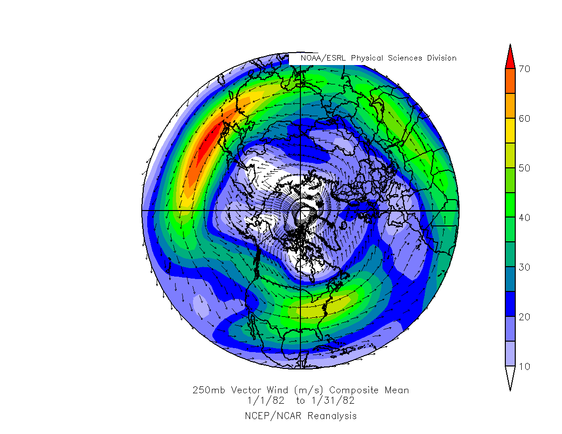
    Considerable effort drove me to determine the reason why Arctic 2013 was so much adiabatic in nature.  The very reason why Cyclones were extremely prevalent especially
from the spring onwards,  ultimately leading up to affect the sea ice minima,  by severely reducing sea ice compaction,  in effect stunting a sure to be greater melt than 2012.  Adiabatic air welcomes cyclonic invasions,  while stable much colder surface air acts as a barrier,  a wall against cyclonic penetrations.

    As you may read my spring based 2013 projection as seen on top of www.eh2r.com ,
the cyclonic activity to come was observed quite entrenched by affecting refraction effects.  Adiabatic surface to air interface dominated spring 2013 so strongly that I was certain and had no doubt that this feature will continue.  However,  early 2014 refraction optics show great evidence of the resumption of more normal Arctic Archipelago weather,  having a greater balance between adiabatic and stable upper air profiles.  In no
small part due to thicker sea ice between the channels caused by summer 2013 not having a great deal of sun ray heating of the sea by the everlasting presence of clouds
which permeated the entire 24 hour sun light season

     Triple Green flashes (seen red because of the filter) on top the much flattened setting sun of March 15 2014.    Clear signals by the heavily stratified nature of the lower atmosphere,  a sign that sun rays traversed an anticyclone.


    Same day right after not so famous but awesome sun line,  not seen like this so bright and strong for years.  
   The sun here is seen entirely compressed about 30 times.  Looking like"fire on the ice".
The sunset ended -2.23 degrees below the astronomical horizon.  Below -2 degrees sunsets were quite rare over the past 8 years.  The thicker sea ice of the Northwest passage cooled faster after a day of sunlight hitting it,  this created many isothermal layers right above,  since air didn't cool as rapidly,  ideal conditions existed for refraction ducting.  

     The basic difference between 2014 and 2013 is a presently colder Archipelago influenced by a a very frozen continent to the South,  in part created by strong albedo action from last summer overwhelming presence of clouds associated with persistent numerous cyclonic incursions.   This long streak of cyclonic activity is currently loosing steam because the local sea ice in a large area is healthier thickness wise,  at least around the archipelago, which is  a much colder area than the rest of the present day Arctic which has had a very warm winter.  The resultant after effect of newish anticyclone genesis should eventually  trigger the return of  more sun rays reaching the the most frozen side of the Arctic.  But since there is a temperature dipole in place, the rest of the Arctic Cyclones should continue enveloping the anticyclonic colder zone.  The very existence of stable air at the surface over the cold area will move about its source,  in effect creating more compaction,  and surely a lesser sea ice minima than last year.  WD March 15, 2014


Thursday, March 6, 2014

Warming in the Arctic blasting cold waves Southwards?

~ Apparently the Arctic can do 2 things,  either it has a deeply frozen atmosphere  spreading outwards or be warmer at once.
600 mb temperatures closely represents the temperature of the entire troposphere.  Courtesy NOAA.  February 1982 (left)  Arctic Atmosphere was extremely cold almost covering the entire Arctic
while February 2014 (right) was substantially warmer,  with a much weakened Arctic Ocean winter.   Lame ,  more than twice smaller.  


How can most presenters claim Arctic blasts  lowering the temperatures enough in Eastern Mid North America to almost freeze the Great Lakes completely,  when a really cold historical Arctic had less an effect on the same lakes?   The answer is spatial compression and also a greater potential of heat radiation to space over the continents primarily because the continents cooled more readily as they are physically unchanged, opposed to a cloudy Arctic bombarded with Cyclonic intrusions having changed Sea ice wise.   


The latest North American "Arctic blast"  was influenced by a very small Archipelago cold air vortex,  the Cold Temperature North Pole (in blue),   which grew significantly in size and cooled further over Sub Arctic!  It was  not quite an Arctic blast.  NOAA's satellite 
missed some extent of the boreal forest area cooling in Mid-Quebec,  radiosonde measurements there were in excess of -43 C at 600 mb.  But the rest of the Arctic ocean 600 mb temperatures were more than 20 C warmer.  

The also common saying "the Arctic Cold air" was replaced by advection from the South, "pushed away" by advection.   Not quite so.   Over the Archipelago,  where the coldest air was during Feb 23-26,  the air warmed from a trough of warm air extending itself from a Baffin Bay Low pressure along with and incursion of warmer air from the North!  Originating from the North Atlantic no less. The Archipelago atmosphere primarily warmed literally from above both ways,  from Latitude and altitude.   The correct interpretation of the latest "blast":  the remnant of coldest winter formed greater over the Boreal zone,  it was a Boreal blast!  WD March 6, 2014    

Monday, February 17, 2014

The Polar Jet streams further North


   Let us take 2 known climate records from history,  the very cold winter of 1981-82,  cold either in Europe or North America,  and the very strange winter of 2013-14, cold in some places and warm in some others.  On NOAA climate composite chart on top we can see jet stream largely Southwards compared to January 2014 being largely more jagged  and more to the North.


         Reason for 2014 extreme North Pacific location may have something to  do with North Pacific temperature anomaly and extremely much warmer Arctic Ocean air temperatures.  On a whole the Polar Jet Stream must and did move Northwards as it is overall warmer in 2014 compared to January 1982.  This 2014 pattern gave the strange weather like California drought,  weird cold winter storms in SE US,  massive storms from one strong Cyclone after another hitting and flooding the British Isles and Ireland,   a warmer Olympics even if it is in Sochi.  Finally a much warmer Arctic warmed by the same Cyclones hitting the Isles, and also from Cyclones coming from the North Pacific.  Warmer over all weather means the Jet streams moved North and meandered more steeply, causing unusual patterns creating havoc instead of more predictable weather.  WD February 17 2014...

Friday, February 14, 2014

Great sea ice melt mechanics

~2013 minima results needs be explained
~2014 melt gearing up to be big


Continuous warm anomalies over the Arctic Ocean have been as incredible as the lack of sea ice compaction last summer.  Both result from the same polar vortex wave arrangements, almost  unrelenting like UK storms which flood the Isles and head towards the Pole.  So I am truly not surprised about current low sea ice extent, it was suggested at the time of last minima by the very same cloudy cyclonic coverage which made the minima bigger.  Again the big question is whether sea ice compaction will return come this summer,  if it does,  I can easily foresee a greater melt than 2012.  That is the big if.  Something must ward off these cyclones from hitting the High North so often, particularly the pack ice center.  This something may be El-Nino or more likely a low sea ice extent area of relatively thick ice in the spring. Once the Polar shores are free of ice, a confluence of regularly positioned cyclones may return the Basin Gyre clockwise.  One over Barents and North Pole, the  regular expansive Baffin Bay Cyclone and lastly  over East Siberian Sea.  These 3 will generate an anticyclone covering the remaining Pack ice.  

        Arctic Ocean  shorelines with open water create anchors or stabilizes Cyclones to remain on top of water.   A near persistent Low centering the Arctic Basin, same as last summer, may bring a cold spring .  Ice clogged shoreline areas favor Highs instead of Low pressure cyclones fueled by water.   An earlier than expected shoreline "spring break" of the entire Arctic Ocean sea ice area may change polar patterns though.  Weather patterns rarely remain the same forever,  when they appear to do so,  they set up the new weather system arrangements to come.  


  Search for "Spring Break"  2013;   


      "Spring break" is seen when the entire Arctic Ocean pack gyrates almost uniformly, when it appears to be free from its connection to land,  the best way to see it is with satellite picture animations,  single high resolution satellite pictures do not reveal this event well:

   2007 sea ice looked better than 2013 on the same May date.  But the end result  at minima was different.  


     Although by May 14 2007,  the entire sea ice broke free from shores and rotated clockwise for the first time:

      Using available animation, when the big lead off the Canadian Archipelago coast spanned all the way to the Atlantic,  the entire ice pack was seen rotating on May 14 2007.   It was the beginning of one massive melt of even very thick ice.  


    2013 had a different look, plagued by steady Low pressure cyclones over the Arctic Basin, which killed the usual compaction favoring clockwise movement of sea ice.   By August 2013 the melt was strong but stayed in place, favoring 
a wider over all extent of loose pack ice.     But by mid May 2013 there was no apparent "Spring Break"  until August with available video   from NASA.

   The entire Arctic Ocean ice didn't appear to turn clockwise at all,  it was an anti-compaction melt season.

      There were those who believed 2013 was a "recovery"  from previous torrid melts.  But these suggestions were ignorant about the holistic nature of sea ice.  It was not a recovery at all, but another great melt which didn't move normally. A continuous repeat of the same weather pattern causing this unusual lack of movement is highly unlikely.  But even if it does,  the sea ice will melt just as much but apparently more slowly year by year.  But I'd expect the return of the Arctic basin Gyre because the clouds have created a lower extent of thicker ice, this will allow an earlier spring break. WD Feb14,2014