Friday, January 24, 2025

More Never seen before sea ice events; the "big lead triples", and wide openings North of Greenland in January

 ~These are absolutely clear signs of a different Arctic winter sea  icescape. 

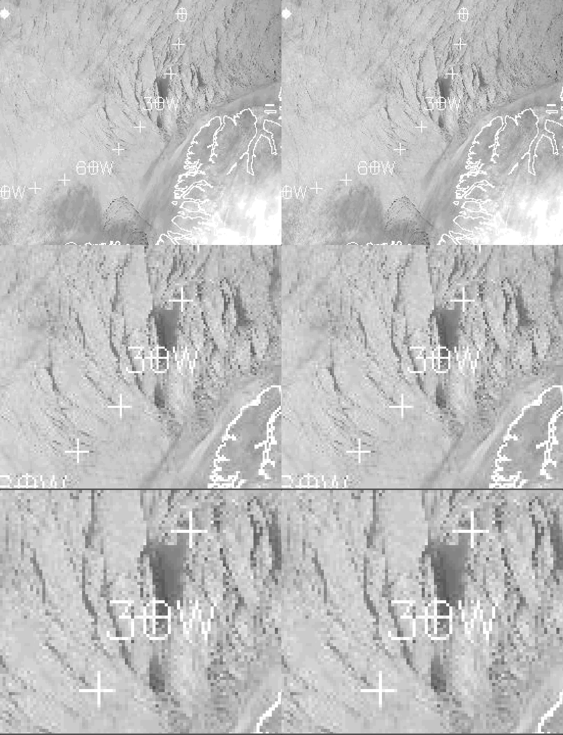
NOAA HRPT infrared picture, January 24 2025.  There are 2 "big leads" quite distant from Canadian Archipelago shore,.  These are mostly tide constructs along with winds. The "big lead" use to be a controversial subject originally described by the early North Pole explorers, the likes of Peary and Doctor Cook some 120 years ago.   The advent of Polar orbiting satellites proved them right. But the traditional "big lead" usually formed NW along side right near the archipelago.   Now there are 2 more of them...


    Note, the map overlay is offset, in green is the original location of the "Big Lead",  there are still signs of it here and there.  The historical "big lead" can be many nautical miles wide, appearing especially at or near full or new moon days.  In red, are the new ice order leads, distant and far away from the coast, likely due to the thinner state of sea ice.  

 Next Extraordinary appearance of wide open water, North of Greenland:


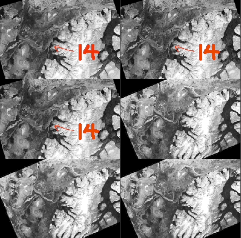
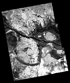
A remarkable, extraordinary NOAA Infrared HRPT ,  January 16 opening seen where usually only thin leads occurred, there is a water sky, on the East side of the opening from an open water source.   North of Greenland  ocean is where sea ice is pushed outwards to the East and South aided by tides.  All kinds of activity happens there,  numerous North South thin leads were the main features, indicating pack lice breaking up.  But these where only on Greenland extreme NE shoreline, the break zone now extends much further westwards   On Radarsat it looks even more chaotic: 


North of Greenland January 15 and 24, 24 has many more dark openings especially on the coast line...   Very strange, never seen midwinter event.  Again signalling a more fragile and overall thinner sea ice, breaking up wider more easily because it is less dense.   WD January 24 2025


Thursday, January 16, 2025

Canadian Arctic Archipelago Arctic Ocean significant Tidal Zone moved South

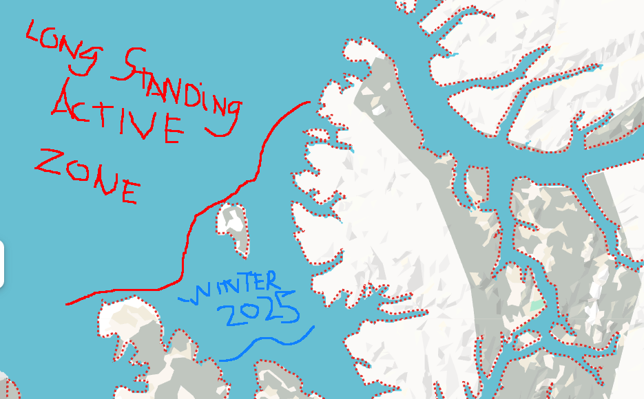
 ~The active Arctic Ocean  open water tidal zone moved 170 Km Southwards in 2025


Just North of Amund Ringnes, circled in red, is an active Tide Zone , as of January 14 2025, way South of where it use to be. 


RADARSAT Canada expanded viewNovember 28 2024 and January 14 2025, really brings out a wide active zone, which opens and refreezes again and again just North of Amund R. .  The Arctic Ocean zone of activity was further to the North between the Northernmost tips of Elef Ringnes  (extreme top left) and  Axel Heiberg (extreme top  right) Islands, just North of Meighen Island, the little one in the middle in between the two.
Remains to be seen whether this new Active zone will last all winter. WD January 16, 2025

Tuesday, January 7, 2025

EAST Hudson Bay wide area boating season January 5 2025

 ~A current live event for Anthropogenic enhanced Global Warming.

~ Following up from this EH2r article: "https://eh2r.blogspot.com/2024/12/hudson-bay-revisit-wide-open-water.html

JAXA University of Bremen Sea ice extent , Hudson Bay complete freeze-up will be very late this season, a wide open boating season continues far off the entire  East Coast.. As of January 5.  


 "Freeze-up begins along the northern shore in September and gradually ex- tends southwards and eastwards. In the southeast, freeze-up occurs last, typically around the first of January. "  Eric Danielson Jr U. Of Calgary:

                Danielson's 1958-1965 data analysis.  Freeze up date boundaries,  truly tentative data though

From Sven Sungaard an important Graph:

     November 12 Hudson Bay sea ice extent 1971-2023.  1998 was a true starting point for Arctic wide perception of extreme warming.  Now lets look at Nov 12 2024:

"0" 

                                                                 Nothing! Apparently no sea ice.

   It is 19 days later than November 12  when a thin sliver of sea ice appears this season.....


Recent world wide warmest years in history had 100% coverage mainly around Christmas.  Current Hudson Bay complete freeze up awaits a date.  WD January 7 2025


Monday, January 6, 2025

Never seen before redux, this time just North of Amund Ringnes Island

~A tidal lead never seen before in January:


                                                  Surrounded by red dots Amund Ringnes Island

    Very rarely mentioned, nor frequented, Amun Ringnes Island fame occurred long ago when it was first discovered in 1900 by Otto Sverdrup a Norwegian explorer. 

Just to its North a Tidal lead which opened about a week ago:

   Onto itself, Arctic sea ice Archipelago channel wide tidal leads are more frequent in the spring to fall, not in January, very few occur nearly year round, they are mainly caused by strong tidal currents.  Detected by NOAA Polar Orbiting Jan 1 2025 high res satellite.  This Amund Ringnes never seen in January event, is merely an extension of the Arctic Ocean lack of thick or ridged sea ice in the not so long ago past assuring a winter permanent presence of ice at the same location, there was no such wide openings possible. 

 A closer look Radarsat look at the lead , January 5 just frozen, but appears to break open often as frozen tide lead lines indicate.

WD January 6,7  2025  

Wednesday, December 25, 2024

Hudson Bay revisit, wide open water Eastern quadrant, less cloud effect.

 ~Surreal open water end of December, Hudson Bay illustrates Earth Warming fast

JAXA Dec 23 comparison , sea ice extent, 2012, 2016, 2023, 2024 ; respectively year of:warmest sea ice melt in history,  2016 very powerful El-Nino, last year middle of a milder El-Nino than 2016 , current December 23 (2024).

    It is fair to say 2012 greatest sea ice melt in history would take longer to recover, it is equally succinct to demonstrate warmest El-Nino effects should be bad for sea ice in 2016, Hudson Bay started to show even slower refreeze in 2023, but 2024 surpasses them all:

   December 23 2024,  incredible certainly for the people living on Hudson Bay Eastern shores. 

   Sea water usually doesn't freeze at -1 C unless 2 m air temperatures are about -11 C or colder, in especially calm winds:


CMC 0 C degree sea surface temperature line way North.

    Albedo caused by near 0 degree Centigrade fog and clouds gracefully slow down Arctic Ocean sea ice melting totally during summer.   Hudson Bay gets less of this happenstance because it is surrounded by land, once upon a time more frozen for a long period of the year.   Not anymore, since mainly from the West air circulating over drier vast lands eventually sheds its total moisture content, causing more over all sunshine. Equally these lesser clouds over H.B. bombards its sea water to be warmer, the surrounding lands likewise.

       The lesson here is that faced with a lesser cloud summer event, the Arctic Ocean sea ice would pretty much easily disappear at extent minima.  Hudson Bay total sea ice cover, once a beginning of December event, now moves forward into winter not as fiercely cold as it was just a few years ago.  WD December 25, 2024. 

Sunday, December 15, 2024

Enormous heat from thinner sea ice blunts and deforms world wide winter circulation

 ~We look at the source of strange weather holistically, but in particular where it is more perturbed.

~Hurricane like heat injects into the Arctic fall and early winter atmosphere simply because Arctic sea ice is thinner. 

  Voyage of the FRAM, Nansen Norwegian polar expedition, 1893-1896.   On the red trail above, Arctic sea ice was recorded to be 3.1 to 3.8 meters thick.

    Same track DMI Dec 15 2024,  gives a thickness nowhere close to 3 meters, something like 0.5 meters at start of famous expedition journey.  

     O.5 meters of sea ice, spanning a huge area gives off close to 100 Watts/m2 heat into the Arctic Ocean atmosphere directly above,  in total darkness,  compare this to CO2 contribution of 4 Watts/m2, consider this warming giving a glimpse of things to come. Remember Nansen reported 3 meters thickness, this capped the Arctic ocean heat transfer almost completely then.

What does this heat injection do?:

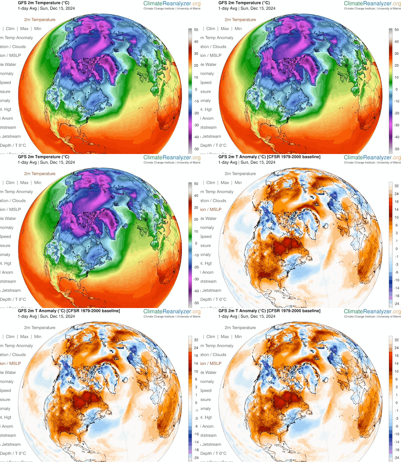
U of Maine Climate Reanalyzer,  thinner Arctic sea ice heat injection to the atmosphere, literally shows up almost every day as a warming directly into Polar darkness.  Making a definite very strong contribution to 2 m surface warming.   In turn, the alteration of sea  icescape thickness modifies planetary waves morphology, these are Polar Vortex contortions, greatly affecting weather everywhere onto the warming caused extremes everyone experiences.  WD December 15 2024 


Wednesday, December 4, 2024

Thinning sea ice looks like no other time, but extent results don't show it

 ~  Amazing degradation of sea ice tidal ridging zone in one year

This was the sea ice picture of 2023-24,  the freezing in place of new sea ice, a huge area, not destroyed by daily tidal ridging, the black area North of Axel Heiberg Island  (the Island with Fjords at right)  

   December 23 2023 Polar View High Resolution image of a huge area of sea ice lasting all winter.  A first in the corrupted by AGW Arctic Ocean sea ice. Although winter 2024-25 has not as large fast thin ice area at freeze up,  over all sea ice condition is worse in a vaster expanse: 

  Same area onset of winter freeze, December 3 2024,  but there is an even greater cumulative  area of thinner and broken up sea ice, giving a loose pack ice look North of NW Canadian Archipelago Islands.  This is a view of the last stand of Arctic Ocean summer sea ice, before there are none in summer, what is left of the thickest sea ice is badly broken up.  I suspect that next December 2025 will look even more grim.  This area has great tides from The Northwest, ensuring ridging or the thickening sea ice by the sheer weight of massive sea ice folding ice sheets on top of each other, but if the greater Arctic Ocean pack ice is equally thinner the ridging mega push looses strength as was the case for winter 2023-24

    Heat radiation gained to the atmosphere by much depleted, thinned Arctic Ocean sea ice is enormous. This significant feature will reduce the shape and extent of the coldest Northern Atmosphere  (The Polar Vortex) during winter will affect the climate of every Northern Hemisphere location.  WD December 4 2024  


Sunday, December 1, 2024

Abnormal beyond model warming; One big reason: Slower moving circulation caused by vanishing thinning Arctic sea ice

 ~Interesting article by GSC Gavin Schmidt, a must read:  https://www.nytimes.com/2024/11/13/opinion/climate-change-heat-planet.html

~Most can be indirectly understood if you read my latest of many similar yearly April climate Projections for the summer fall:

https://eh2r.blogspot.com/2024/04/2024-summer-fall-projection-forecast.html

The reason why the warming is greater for the Northern Hemisphere is simple, Arctic sea ice reduction in area and thickness surrounded by continents.  For this we must look at NASA GISS:

                  Annual mean Land-Ocean Temperature Index in 0.01 degrees Celsius
                                      selected zonal means
                                      --------------------
                    sources:  GHCN-v4 1880-10/2024 + SST: ERSST v5 1880-10/2024
                    using elimination of outliers and homogeneity adjustment 

                         Note: ***** = missing - base period: 1951-1980  

                           24N   24S   90S     64N   44N   24N   EQU   24S   44S   64S   90S
Year  Glob  NHem  SHem    -90N  -24N  -24S    -90N  -64N  -44N  -24N  -EQU  -24S  -44S  -64S Year
2021    85   114    55     143    65    53     206   136   127    72    58    72    33    30 2021
2022    89   116    62     152    56    70     235   150   127    62    51    78    40   108 2022
2023   117   150    85     178   106    71     258   187   147   108   105    90    45    62 2023
Year  Glob  NHem  SHem     24N   24S   90S     64N   44N   24N   EQU   24S   44S   64S   90S Year
                          -90N  -24N  -24S    -90N  -64N  -44N  -24N  -EQU  -24S  -44S  -64S
 The zonal mean 64-90 North and South says it all.  There is a continent wide Glacier at the South Pole, while at the North Pole there is a continent size Ocean covered by sea ice.  If this sea ice vanishes,   something likely to happen during a coming summer, temperatures at North Pole Region would warm much more.  At the moment, the warming is gradual but close to 4 times faster compared to the Antarctic.
    A slowing of global circulation is a symptom of massive temperature differentiation from one temperature zone to the next,  as the Arctic sea ice disappears so will the Northern Hemisphere swift weather events usually lasting a day or so, temperatures between the North Pole and Equator will be significantly less, engendering slow to sluggish circulations causing catastrophic events to linger, such as Typhoon/Hurricanes moving slowly over a populated area, as already happened.  Causing entire regions languishing under same weather conditions for days or much longer,  such as excessive droughts, never ending heavy rain periods as has happening more recently again.  
   July peak record breaking temperatures way above climate model projections (NYtimes article) is an indication confirming that Northern Hemisphere is warming faster than the South, largely tempered by massive Oceans and said huge Antarctic Glacier.  There is ample evidence of Arctic sea ice changes, suffices to say, its state is nowhere similar compared with a mere 20 years ago.  Especially autumn and winter ice topography, recently more broken and with open water, along with the warmed Oceans have caused our present delay of onset of winter worldwide.  WD December 1 2024
 

Sunday, May 19, 2024

Introducing the Optical Ancient Chronology , using archeo-astronomy enhanced by refraction science

~The importance of an accurate Ancient Chronology helps explain climate induced historical events, some spanning for decades.  For instance, incredible monuments like the Giza Pyramids were not built during massive droughts, of which devastating famines following their construction caused a lost of technological prowess which built them in the first place.  Or for instance, the rise of Egyptian 18th Dynasty New Kingdom which started by expelling the Hyksos, the latter likely weakened by another disastrous drought period.  Following of which in the middle of the 18th,  Pharaoh Hatshepsut temple was built during an era of normalcy giving prosperity, sustaining an Ancient Egyptian renaissance period re-establishing the building of magnificent monuments and structures.

~Today's Anthropogenic enhanced climate change is much compensated by modern technology, but the limits of this techno driven world are already being tested, in the form of civil strife and mass migration. Given that much of the world's population are living day by day, at the razor edge of survival, a prolonged climate event, such caused from AECC, makes for great motivation to leave a day by day razor's edge existence to desperately migrate to the countries who fare better despite extreme weather events.  

~History is full of  pre industrial climate disasters, even though they didn't last very long (decades to 100 years or so).  None more salient than the 12th century collapse of the Bronze age Mediterranean civilizations, or the greatest example of our ancient past,  the collapse of Ancient Egypt Old Kingdom.  

 ~ Being so fitting we start with 4 optically aligned years,  all ancient Egyptian.

~All can be refined given better data, note most  data is taken from what is available online, Google Earth can regionally be accurate if proven so.  Far better on site research with the highest precision GPS instruments can ultimately lead to more solid dating. 

NOTE : these dates are tentatively close, some will likely change. They are presented in order of discovery

KMT 1

2370 BC ........ A KMT 1, Ancient Kemet/Egyptian 1,  start of construction year of the Great Pyramid, Pharaoh Khufu coronation 2340 BC, followed by coronations of Djedefre, Kefren and Menkaure between 2340 and 2302 BC, in the Queens chamber of the Great Pyramid.

          Astronomical prowess of Ancient Egyptians need not to be reintroduced, the very orientation of the Giza pyramids is self explanatory. But these pyramids reflect a stronger adherence to the upwards sky absent of refraction, except for the Sphinx gaze to the horizon, which has a strong refraction component, making it not as stable with respect to precision, perfection.  The Great Pyramid was based on the transit equivalency of Sopdet/Sirius and RA/Sun occurring 30 days before the winter solstice (in 2370 BC).  Khufu Ahket, the name of the great Pyramid as written then, meaning the horizon of Khufu, has a relation to the horizon only with respect to the sunrise at the equinox.   

KMT 2

1313 BC  Amenhotep IV, Akhenaten Coronation year.  Akhenaten tried to re-establish the solar RA dominance in governance, replacing Amun as the God of Gods and placing RE or the Aten as the God which can be always felt and seen. 

          There are several corroborating monuments and historical findings which tend to agree with 1313. Namely the alignment of the Great Aten Temple at Akhetaten or Tel el Amarna.  Two boundary stelae proclaiming in a very clever secret way the date of Akhenaten coronation,  a new hieroglyph inspired by a blue refracted hourglass sunrise, only possible at higher elevation horizon as found at Akhetaten/Amarna [involving heavy refraction science ].  The dendrochronology dating of the Uluburun shipwreck dedicated firewood for cooking, 1305 BC,  also found on the wreck;  a gold scarab of the great wife of Akhenaten, Nefer Neferu Aten, or Nefertiti, not co-ruling yet.  

                                   Clean air blue sunset or sunrise upon a higher horizon.  

KMT 3

 3422 BC.  Pharaoh 0,   the first Pharaoh was crowned when the winter solstice transit sun was at the same altitude as Sirius at transit.  From this time onwards, Sirius/Sun Transit equivalence drifted earlier in the year away from the winter solstice, this is the proto genesis of all Pharaohs of especially the Old Kingdom mainly upwards look at the sky.  This was a quasi refraction free high precision moment in time. 

KMT 4

   1427 BC +/- 20 years based on 116.767 degrees Azimuth dot sunrise    Hatshepsut temple at Waset/Luxor/ Deir el Bahri, aligned with the winter solstice sunrise, designed by her vizier architect and astronomer Senenmut.

        Caution must be taken with Google Earth accuracy, therefore the large +/- variance in dating. Some GE regions of the world may be well off, some others like at Luxor apparently not. This can be much improved by high precision in situ GPS equipment. 

A paper:    " Studying the Orientations of Luxor Ancient Egyptian Temples Using QuickBird Images"

By Mosalam Shaltout and Ahmed Ibrahim Ramzi

1. NRIAG (National Research Institute of Astronomy and Geophysics), Cairo 11421, Egypt 2. NARSS (National Authority for Remote Sensing and Space Sciences), Cairo11421, Egypt  "  

 Gives  a bearing of  116 degrees 4834.44".  116.746 degrees Azimuth. While using Google Images GEO Eye-1.

    The sunrise dot as seen from Luxor Eastern then pristine mainly pollution free hill scape can be less than 8 arc seconds in width.  While using Laskar latest declination formula, and considering a near constant refraction value from higher elevation horizons, as derived from local Upper Air archives.  The winter or summer sunrise solstice is likely the easiest horizon high precision astronomical bearing (if not the only one) which can be found within a few years of observations. In Ancient Egypt, this certainly became an understanding which prompted a shift in building philosophy which in its past was particularly designed to avoid refraction effects, from the Great Pyramids, inspired by well above the horizon gaze, to the Middle and New Kingdom temples of the Nile Valley, being mostly sunrise dedications having the same astronomical alignment accuracy as the pyramids, achieved without expending far greater resources.  Hatshepsut temple was likely aligned with the predynastic concept of the original pharaohs being Gods, ie pharaoh 0, since Hatshepsut claimed her father being a God.  Hatshepsut  coronation/dedication had exactly the same sun shaft as with the Great Pyramid Queen's chamber. except it was much miniaturized in length but aimed at the horizon like the Sphinx.  And she was known to have made built a lot of sphinxes.

               An 8 Arc seconds wide sunset, it can be just as much a sunrise dot.  These are easily seen by normal eyesight alone. The perfect positioning with respect to Hatshepsut Temple needs a flat leveled field, such as found in front her temple.  Then by means of thin rods,  suspended plums or even stones, a repeat alignment of the furtherest South winter solstice sunrise may be replicated on a few occasions, identifying the true solstice bearing.  During such alignments, a small shaft as found at the temple, may be built with the comprising solstice sunrise dot at the center lower shaft bottom, this permits subsequent years whole sun to penetrate the inner sanctum starting center left if the air is heavily refracted, or drifting from center to the right after normal average refraction sunrise.  Thus a small wall with square shaft may be built first before the entire temple structure is built around it.    


More to come Looking for historian or Egyptologist to co-write for peer reviewing please reply your interest here in the comment option by saying hi,  will see your email thereafter.

wd May 19,21,, 2024


Thursday, April 25, 2024

2024 Summer Fall projection forecast based on Arctic in origin synopsis

~ Similarities with recent years may be few

~Very late Arctic Basin High to Low pressure switchover is expected


April-May


   Clouds domination affect two primary weather parameters, one is snow on the surface, two is apparent slow melting of sea ice.  In other words, an apparent cooling will be the result,  building cold High pressure systems, which become stable over the Arctic basin Gyre until a switchover occurs, this when cold surface air is part of a summer Low pressure system. There should be a High pressure system dominating most days over the Arctic Basin Gyre throughout this period. The extra snow is a proxy for sea ice, it is not as stable as sea ice, from snow sublimation and under sea ice warmer water temperatures.  The thinner sea ice area come June and July, bereft of snow, will likely maintain a summer High pressure system, favoring warmer air. Thereafter, when the ice melts, open Polar cooler ocean becomes the main main attraction for Arctic summer cyclones, so switchover is expected in late July primarily because winter heat imprint on sea ice on the Canadian side of the Pole is far stronger than on  the Russian side.  This late switch in pressure system locations would have been much earlier given a CTNP dominances on the Canadian side, that was not the case.  A double H high pressure symbol,  from blue to war red, indicates the evolution of the nature of anticyclones when spring turns to summer. The cold nights and low noon sun of spring favors High’s being cold, eventually the sun gaining height in the sky literally changes the nature of pressure systems. A Blue High indicates a stable much slower transition, like wise with cyclones which are usually always cooler in summer, but except for in origin warm sea cyclones,  including intense hurricanes. 


June-July


    The Arctic basin Gyre will be blasted by more sun rays than usual on account of a late pressure switchover, at about mid July onwards the extreme sun bath slows down.  Desert High Pressures will expand in extent Northwards in both America and from North Africa.   The Lone CTNP cell will hang about Russia, apparently causing a delay in ice melting there.  The Polar jet stream will collapse in pieces  but along  near this cell.  Cold surface hugging cyclones will dominate wherever open water subsists, one must remember the effects of El-Nino worldwide extra clouds on creating extra precipitation, making their final disruptions, mid west North America late July onwards.  The dissolution of the CTNP will finally entail a strong late melting rate on the Russian side of the Pole, 


August-September


   Unfortunately, predicting that there will be another great sea ice melt is easy, its final form, extent and where it melts not so.  Eventually as August progresses Greenland takes prominence as the only Mega albedo area in the Arctic, it should become the CTNP, but its altitude prevents this, however remnant Arctic Basin sea ice will team up with Greenland to form the new Polar Vortex of sorts, hence a zone of High pressures to the North and Southwards of Greenland will be encroached by slow moving cyclones. East of Greenland median cyclones often to become quasi stationary over open vast open sea water areas.  To the West of Greenland median ever so inching Northwards cyclones appear to  struggle moving North by Synoptic weather systems.  Western Europe and Central North America will have  significant slow moving High Pressures not part of the desert anticyclones further Southwards. As El’Nino does not usually foster numerous hurricanes , the few will be caught from being quasi stationary by the elongated Greenland Southern High pressure, ensuring slow rotational death at sea in the East Atlantic, or slow encroachment Northwards joining the Eastern North American seaboard.  Not like typhoons venturing further  North than ever thought possible.  The biggest problem for a complete Arctic sea ice melt will continue, mainly by two factors; waning El-Nino twinned with the ever so persisting North Pacific surface sea water high temperature blob, a perpetual cloud machine.  I’d expect a greater melt than 2012 but not by much, Arctic basin sea ice remnants at minima will look awfully battered and emaciated though. Freeze-up in October will permeate the Arctic Ocean shores with even more fast ice extending much larger than October 2023.   If the Arctic Ocean winter come December looks like a dark ring of thin ice throughout the entire inner Sea, 2025 melt will finally clear at the Pole. It was amazing to witness thick pack sea ice not overpowering the much thinner NW Canadian archipelago expansive dark fast ice all winter.   The end of summer sea ice is nigh within a few years if this dark ring occurs.  In the mean time, Canadian side 2024 Northwest passage will open first before the Russian North East one, however the broken ice from the larger Basin will clog channels up for a while.  


    Over all weather is what you’d expect from the last few years except for the greater moisture impact El-Nino gives, a tandem dynamic effect in the Polar regions was and is a significant CTNP shift towards Russia, it is very unlikely that weather in most parts of the Northern Hemisphere will be the same as Summer 2023.  Rather the only thing similar is the slow sluggish movement of weather systems, obviously under more rainy conditions, that is a key difference , but not where massive anticyclones hardly move.  For some celebrate during  great sunny weather days, for others too much every day solar heat than desired induces Air Conditioning isolation inside the smaller world home, too much of any weather feature is never pleasant.  The consequences of slow moving pressure systems give simultaneous extreme weather differences within the same continents, ‘extreme lack of familiar weather’  will be key often repeated words surely  to be used.


Extraordinary Polarview central Northwest coast of the Canadian Arctic Archipelago black fast ice (2024/02/18), fast ice is first year ice while the white ones are multiyears), stayed like so the entire winter, while in a few years past would have been easily crushed when first formed in late autumn.  


Shoreline black ice survived all winter long well into the spring,  and is now moving with rest of Basin pack after early spring break.  Such ice, thinner and new year, ringing the entire Arctic Ocean Basin shoreline in October would be a bad presage announcing a coming wider if not complete sea ice melt.  


     NOAA sea surface temperature page, the great Pacific high sea surface temperature blob survives still, except a bit weaker, nevertheless a great cloud enhancer considering even a weakening El-Nino combined with every sea warmer, notably and especially the Atlantic and Indian oceans. These are progenitors of heavy rains, and for the Arctic, more clouds.WD April 24, 2024