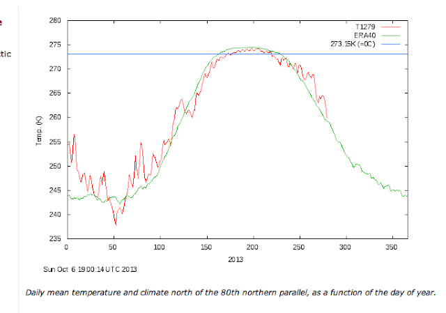
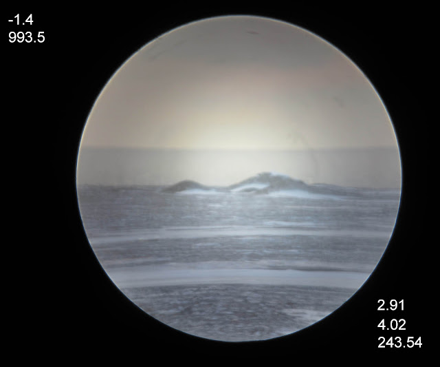
~ Pre paper basics presentation.
~ Ice formation is not strictly the result of colder temperatures
Unlike surface water, sea ice has rapid thermal variation characteristics which enables an instant evaluation of its thickness and age.
Lets go back in time, a March 2004 sunset comes to mind:
Apparent high Arctic sunset disappears in mid air. That was not so. The sunset was much raised with the ice horizon. By 11 arc minutes. The horizon was higher, the entire sun disk transforms in turn. From ovoid to becoming saucer like, eventually morphing to a sun line which was highly compressed sun disk image. Arctic haze, more common then, masked the raised ice horizon. At the time, sea ice over the NW passage was a mix of old and new. Multi-year ice made the onset of freeze-up earlier in autumn 2003. The end result was thicker ice many months later in March when this sequence was taken.
Refraction effects can be even more complex. Horizontal refraction permeated the lower horizon, seeming to dissect the air
layer by layer, making the sun's upper limb wearing a green flash hat, or at the end revealing gravity waves streaming.
Fortunately sun disk effects are much more complicated than the rising horizon. There is so much air thickness between sun and camera which absolutely demands a greater knowledge of great chunks of the atmosphere.
Inspiration to study something apparently simpler came about. To make sense of all these mirages a steadier subject was needed. Elevation wise, sea ice varies throughout the day. Can be studied at any time for days especially with good visibility.
From this visual aspect, using a baseline value for sea horizon height having water and surface air with the same temperature, a retrospect evaluation of sea ice thickness is possible. On this March 2004 day, there was likely a sea ice mean thickness of 3.2 meters over a huge area of the NW passage.
1- Instant Identification of sea ice status, freezing, melting or steady state
Long wave radiation has a way to be revealed, if a body emits a great deal of it, the immediate area adjoined will be warmed. In the case of sea ice, sun rays heats sea ice surface, but warming comes from below as well, Arctic sea surface temperatures are almost always higher than air during winter, this continuously tends to soften the ice bottom making it become brittle or fragile. If the sun is strong enough, the sea ice to air interface looses its boundary layer, or structure.
Steady state:
September 2012 Sea surface temperature (devoid of ice) is equal to the surface air, the horizon is at steady state, it appears at pure astronomical horizon elevation. If the Horizon goes below this level, there is an inferior mirage, the water or ice is warmer than the air. If it rises above, there is an inversion, when so water or sea ice surface is colder than the air.
Melting;
March 19, 2013, seemingly cold -26 C day. The ice horizon was lower than the steady state, the ice is not getting bigger at this moment, more likely melting from the bottom, warm surface sea ice nullifies the inversion above which was keeping the cold air locked, and creates an inferior mirage, similar to road mirage.
Freezing;
Same day but later , the sun is 3 degrees above the horizon, ready to set. Ever since last picture was taken, the horizon rose in small increments, will continue to do so. The steady state astronomical horizon line was exceeded higher, sea ice was thickening. The cold air overtook the heat gained by the sun, there is a net heat lost by the ice. The apparent horizon gain gives away the over all thickness of the sea ice. As a general rule, the thicker the ice, the quicker the horizon rise.
2- Determining ice thickness by refraction
There can be several methods of determining sea ice thickness optically, which means immediately. During the long sunless night, the horizon was highest when radiation escaped to space directly without interference by clouds, which may affect the radiation balance at sea to air interface. On a mostly clear evening the ice horizon peaks after sunset:
From minima day onwards the first onset of thinnest ice, clear sky horizon rose in tandem with ice thickness. One basic empirical rule is 50 cm per minute of arc increase. In this picture above, it means 160 cm overall ice. 255 cm less than compared to 2004 sunset sequence at about the same date.
Applications:
Studying instantly whether sea ice is growing adds a better understanding on how accretion works, in the case of winter 2012- 2013 freezing season, there was melting as early as March 18, at about sea ice maxima peak.
It was short lived by a few hours, subsequently melting grew longer day by day, eventually the melting period of any given day will exceed the freezing once the horizon is lower than a steady state level more than 12 hours a day. Freezing is not a continuous process dependent on degree days, but rather whether the radiation budget of sea ice is in a loss or gain mode. Remote sensing merely calculates the gain or loss of sea ice volume or extent, but horizon measuring explains what is happening directly. The two methods of visualizing sea ice complement each other, and should be utilized in improving sea ice models. WD April 14, 2013
High Arctic Earliest melt, West of Southwest Cornwallis Island
Spring Equinox Freeze up Maxima of Northern Hemisphere
Cryosphere is not a coincidence. The returning sun stops accretion and causes the melting of sea ice, very early on particularly on its bottom. Surface Sea ice may appear cold, normal and well set, but that is not the case on its underside. It may be very cold outside, but sun rays on a clear sunny day have a huge impact over lower accretion action. Above is last 4 seasons spring collage. 2011 was the coldest year sea ice wise. The first column displays earliest bottom melts. 2012 and 2013 had very low horizons way earlier, although 2010 data was scarce in February. Second column displays first extreme low horizons, all within March 11 and March 19, sea ice Maxima period. Third column sets the date when continuous low horizons were seen afterwards. 2011 was particularly good for sea ice preservation. Late February shots were at sun elevations 5 to 7 degrees during Local Apparent Noon. Indicating a sun merely 6 degrees high has an impact over the energy balance of ice. Thus 11.8 to 15 degrees elevation sun causes certain melting on the underside, while 5 to 7 degrees elevation noon sun can do likewise but the conditions must be right, thinner ice and likely less snow insulation may be major factors. 2012 and 2013 were noted as having earliest underside melts, this is likely because of the disappearance of multi year-ice. WDApril 21,2013
Practical examples:
Current NOAA North Pole Cam :
Using fix point reference the radiometer box,
The horizon height should vary, all be it not very high as with examples above. The data acquired from this variation will show the nature and status of the ice. The sun rises very slowly continuously, until it rises a couple of degrees, only clouds will affect the horizon, unless one uses very high resolution programs converting the image, if capable a slow and gradual reduction of sea ice horizon will occur . wd April 20, 2013
A very small drop in horizon has been detected after 5 days. This suggests thin ice melting on its underside. April 21 2013
Lets go Surfing
This method applies for any horizon, including Redondo beach L.A.
Redondo beach L.A. extreme right picture displays a significant drop in horizon at about 1 PM, the effects are very similar to sea ice. The sea surface has warmed due to warm air and High noon sun. The surf looks good from likely sea breeze keeping shore weather cooler. wd april 20
Night time and morning have extreme variations, not as much as sea ice, but noticeable if you take sequence to desktop and zoom. April 21,2013
Really obvious drop at right april 24.
At this beach there is an evening diurnal rise very similar to sea ice, day time horizon drops and night time and very early morning rises. bring to desktop and zoom on image. April 25 2013
Unusual, with sea surface 16C with surface air 16 C. Could be a fog bank on the right picture or the true astronomical horizon. Must observe further.
Observe the significant drop at right, which only means warmer water than air. May17,2013
May 6, 2013:
Redondo beach May 13 near perfect astronomical horizon at extreme right. May 13, 2013
What about Scotland?
Yes variations on Fraserburgh Aberdeenshire webcam show the same drop. But slower,
and at evening end. WD May 1,2013
Scotland never disappoints look carefully:
Warm from land winds have created a great looming or superior mirage seen at far right. Sea water at this time is +6.5 C air going to Northeast at 21 km/hr. The temperature difference is such that the horizon rises above an apparent air layer.
wd0505
Fraserburgh astronomical horizon.
The theoretical perfect astronomical horizon, temperatures of sea surface and air is equal. So far, most of Fraserburgh horizon was high because the water was colder than the air, but here a stint of cold air lowered the horizon substantially. For it to be even lower will likely require winter weather when the sea becomes warmer than the air the horizon will lower further. Note the lower light house pier seems aligned with the perfect astronomical horizon, an accident? Or an architectural master ly design. WD may9,2013
Fraserburgh June 8 sea temperature colder than the air (right) , the horizon goes higher than picture above . WD June 8 2013


