~A refraction magic rabbit (a new way of seeing things, to be published in peer review paper), popped out of the hat in early spring 2012.
~It turns out a very warm spring atmosphere made it possible
~Comparison of top 10 sea ice extent melt follows:

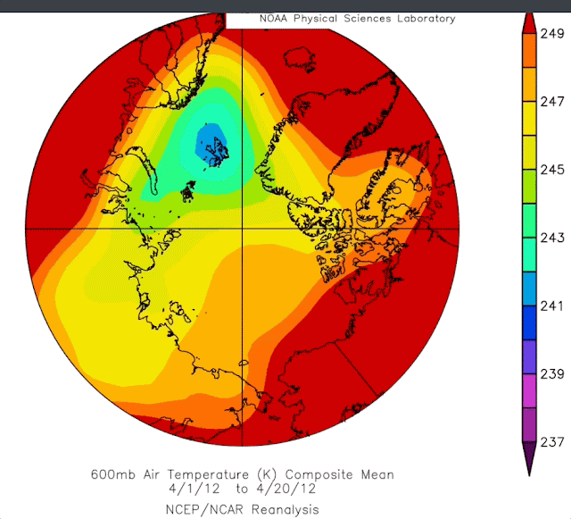
Before we do top 10 sea ice melts, let's look at 2012 vs 1977. 2011 sea ice situation was grim, 1976 was opposite, much more multiyear sea ice was covering the entire Arctic Ocean. This made it easy for the Polar Vortex to be North Pole centric then. Notice the green zone -30 C temperature area at 600 mb height (those favoring 500 mb can be greatly confused by stratospheric influences). 2012 was exceptionally warm for the Canadian High Arctic (so did say the rabbit).

What happened in 2021? After all 2020 was 2nd place in sea ice extent. The vortex regained the Pole,
this guarantied a great influx of clouds from the North Pacific sea surface temperature '"hot" blob, in addition to accelerating importation of moisture by equally super warm North Atlantic, summer Arctic clouds save ice from melting completely hence the appearance of a cold air recovery.
8th Place, 2008 the LaNina Spring super sunshine melt ponds

In 7th position:


3rd sea ice melt place; The great small but very cold CAA Vortex

Spring 2011 was almost bipolar for the Polar vortex, the Canadian Archipelago very strong vortice of the Polar Vortex assured 2 things, dry air from North Greenland towards the Pole and the wet North Pacific moisture trust directly towards the North Atlantic, in imagery words, apt for good solar input for the Arctic Ocean,
#6 2015 the warmest year in history then
The waning -30 C green zone plus the Baffin Bay centric center of the Polar Vortex, similar to 2011, assured 2015 prominence in melting.
#5 The sun melt year: 2007
2007 600 mb spring temperature was practically similar to 2012 the area having the greatest melting by sunshine was North of Alaska Beaufort sea we can see clearly a favorable North Siberian in provenance circulation of dry air.
#4 super ENSO warming; 2016 
2016 green -30 zone shrank to near 2012 dimensions along with a stifling encroachment of red (-24 C) areas all throughout the Arctic , again favoring dry air from Siberia sun warming.

2019 may seem much colder than 2012, however North Atlantic and Pacific had a very warm spring atmosphere. Again key, dragging dry Siberian air over Alaska and Eastwards, The Canadian Arctic Archipelago vortice was measured stubbornly in place for the longest time assuring these dry (less cloudy ) air conditions.

All in all we can now project with a greater deal of precision whether the sea ice minima will be small by mid-April, another prediction tool thanks to said "rabbit" refraction trick which suggested looking at these holistic temperatures. WD October 30 2021
No comments:
Post a Comment