~Today's 2018 JAXA extent is #1 lowest within historical record
~Since minima refreeze pattern almost exact melting in reverse
~There is no doubt that fresh less dense surface melt water is necessary for more rapid refreeze
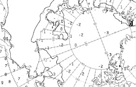
Elsewhere October 21 CMC SST's are still quite warm, it takes -1.8 C water for sea water to freeze. Despite greater darkness 0 C waters North of East Siberian sea is astounding, the Atlantic front ice border remains stable and Bering Chukchi seas super warmed waters guaranty a further slower refreeze, which makes this map interesting:
to this 19 days remove sep 3 JAXA eerily similar map to today absent Fram Strait. The CAB is not refreezing well largely because of great cloud coverage and very warm sst's, which gives a surface temperature feedback loop of warming. These two factors made 2018 overall #1 lowest extent especially along with very thinned central CAB sea ice, made perfectly obvious by the presence of nearly permanent Arctic Ocean overcast with clouds and the lack of an anticyclone over the North Pole, which always happened in the past at the start of the long Arctic night. The biggest news is for larger populations further South, an abnormal winter awaits them.
CMC October 24, sign of compaction in North Pole to Greenland sector, with finally a High pressure, an extension first originating from the Canadian Archipelago South. A very unusual, unique, very loose pack North Greenland sea ice was present throughout end of melting season. Now we can attest, this anomaly has largely frozen over. A North Pole High following Minima usually means the start of winter, about 3 weeks late.
WD October 21, last GIF October 24, 2018


No comments:
Post a Comment